You are here: Home > Network List > UW - Pacific Northwest Regional Seismic Network Stations List
> Station MRBL Marblemount, WA, USA > Earthquake Result Viewer
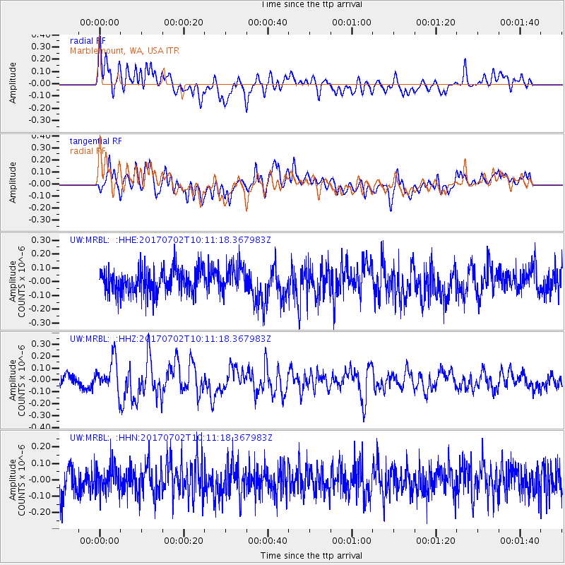
MRBL Marblemount, WA, USA - Earthquake Result Viewer
*The percent match for this event was below the threshold and hence no stack was calculated.
| Earthquake location: |
Kermadec Islands Region |
| Earthquake latitude/longitude: |
-27.4/-176.5 |
| Earthquake time(UTC): |
2017/07/02 (183) 09:58:50 GMT |
| Earthquake Depth: |
16 km |
| Earthquake Magnitude: |
5.7 Mww |
| Earthquake Catalog/Contributor: |
NEIC PDE/us |
|
| Network: |
UW Pacific Northwest Regional Seismic Network |
| Station: |
MRBL Marblemount, WA, USA |
| Lat/Lon: |
48.52 N/121.48 W |
| Elevation: |
75 m |
|
| Distance: |
90.1 deg |
| Az: |
32.985 deg |
| Baz: |
226.743 deg |
| Ray Param: |
$rayparam |
*The percent match for this event was below the threshold and hence was not used in the summary stack. |
|
| Radial Match: |
51.20956 % |
| Radial Bump: |
400 |
| Transverse Match: |
55.799717 % |
| Transverse Bump: |
400 |
| SOD ConfigId: |
13570011 |
| Insert Time: |
2019-04-28 07:58:16.614 +0000 |
| GWidth: |
2.5 |
| Max Bumps: |
400 |
| Tol: |
0.001 |
|
Signal To Noise
| Channel | StoN | STA | LTA |
| UW:MRBL: :HHZ:20170702T10:11:18.367983Z | 2.9722707 | 1.41808E-7 | 4.7710326E-8 |
| UW:MRBL: :HHN:20170702T10:11:18.367983Z | 0.8247443 | 8.078437E-8 | 9.79508E-8 |
| UW:MRBL: :HHE:20170702T10:11:18.367983Z | 1.1694462 | 1.0242747E-7 | 8.75863E-8 |
| Arrivals |
| Ps | |
| PpPs | |
| PsPs/PpSs | |


