You are here: Home > Network List > II - Global Seismograph Network (GSN - IRIS/IDA) Stations List
> Station WRAB Tennant Creek, NT, Australia > Earthquake Result Viewer
WRAB Tennant Creek, NT, Australia - Earthquake Result Viewer
| Earthquake location: |
Myanmar-India Border Region |
| Earthquake latitude/longitude: |
24.8/93.7 |
| Earthquake time(UTC): |
2016/01/03 (003) 23:05:22 GMT |
| Earthquake Depth: |
55 km |
| Earthquake Magnitude: |
6.7 MWW, 6.6 MWB |
| Earthquake Catalog/Contributor: |
NEIC PDE/NEIC COMCAT |
|
| Network: |
II Global Seismograph Network (GSN - IRIS/IDA) |
| Station: |
WRAB Tennant Creek, NT, Australia |
| Lat/Lon: |
19.93 S/134.36 E |
| Elevation: |
366 m |
|
| Distance: |
59.6 deg |
| Az: |
134.637 deg |
| Baz: |
316.59 deg |
| Ray Param: |
0.06196997 |
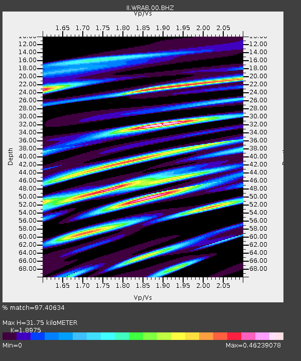
| Estimated Moho Depth: |
31.75 km |
| Estimated Crust Vp/Vs: |
1.90 |
| Assumed Crust Vp: |
6.642 km/s |
| Estimated Crust Vs: |
3.5 km/s |
| Estimated Crust Poisson's Ratio: |
0.31 |
|
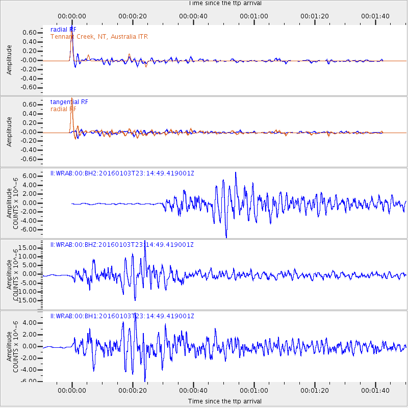
| Radial Match: |
97.40634 % |
| Radial Bump: |
252 |
| Transverse Match: |
92.98802 % |
| Transverse Bump: |
399 |
| SOD ConfigId: |
1379111 |
| Insert Time: |
2016-01-17 23:14:11.147 +0000 |
| GWidth: |
2.5 |
| Max Bumps: |
400 |
| Tol: |
0.001 |
|
Signal To Noise
| Channel | StoN | STA | LTA |
| II:WRAB:00:BHZ:20160103T23:14:49.419001Z | 7.099086 | 1.8933457E-6 | 2.6670276E-7 |
| II:WRAB:00:BH1:20160103T23:14:49.419001Z | 4.935147 | 7.83667E-7 | 1.5879304E-7 |
| II:WRAB:00:BH2:20160103T23:14:49.419001Z | 10.261075 | 8.2989084E-7 | 8.087757E-8 |
| Arrivals |
| Ps | 4.5 SECOND |
| PpPs | 13 SECOND |
| PsPs/PpSs | 18 SECOND |


