You are here: Home > Network List > TA - USArray Transportable Network (new EarthScope stations) Stations List
> Station J26L Joseph Creek, AK, USA > Earthquake Result Viewer
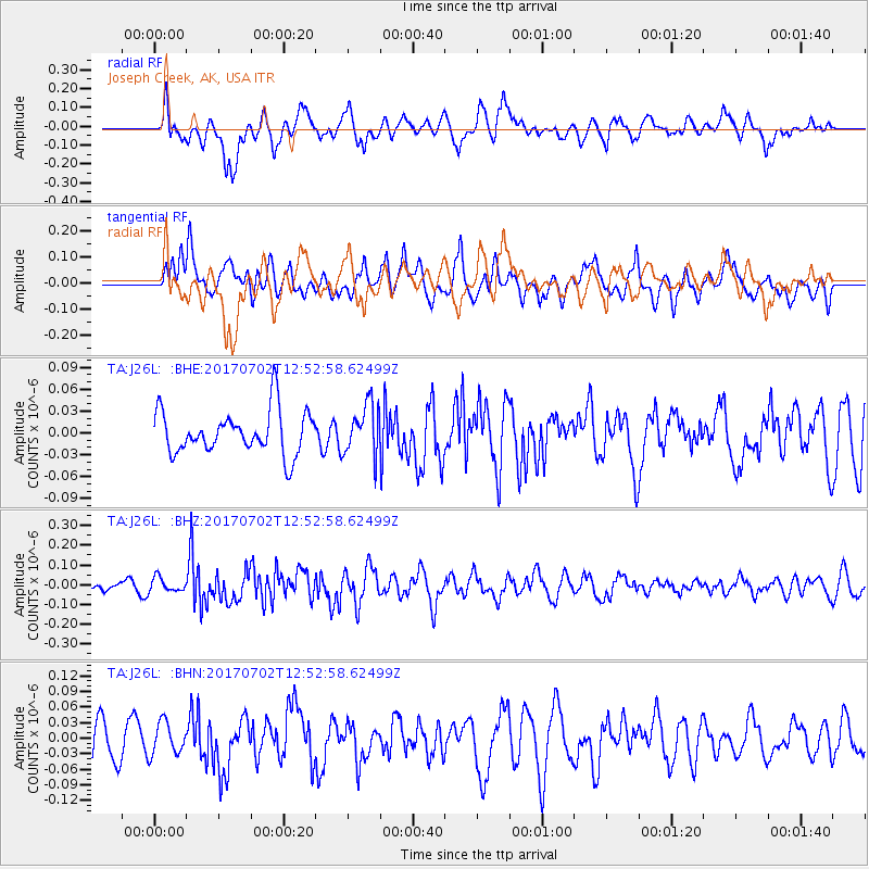
J26L Joseph Creek, AK, USA - Earthquake Result Viewer
*The percent match for this event was below the threshold and hence no stack was calculated.
| Earthquake location: |
Kermadec Islands Region |
| Earthquake latitude/longitude: |
-27.4/-176.1 |
| Earthquake time(UTC): |
2017/07/02 (183) 12:40:05 GMT |
| Earthquake Depth: |
10 km |
| Earthquake Magnitude: |
5.5 Mww |
| Earthquake Catalog/Contributor: |
NEIC PDE/us |
|
| Network: |
TA USArray Transportable Network (new EarthScope stations) |
| Station: |
J26L Joseph Creek, AK, USA |
| Lat/Lon: |
64.50 N/143.56 W |
| Elevation: |
1144 m |
|
| Distance: |
95.1 deg |
| Az: |
13.51 deg |
| Baz: |
208.667 deg |
| Ray Param: |
$rayparam |
*The percent match for this event was below the threshold and hence was not used in the summary stack. |
|
| Radial Match: |
65.18565 % |
| Radial Bump: |
400 |
| Transverse Match: |
52.755894 % |
| Transverse Bump: |
400 |
| SOD ConfigId: |
13570011 |
| Insert Time: |
2019-04-28 08:03:19.947 +0000 |
| GWidth: |
2.5 |
| Max Bumps: |
400 |
| Tol: |
0.001 |
|
Signal To Noise
| Channel | StoN | STA | LTA |
| TA:J26L: :BHZ:20170702T12:52:58.62499Z | 1.1478113 | 3.5755757E-8 | 3.115125E-8 |
| TA:J26L: :BHN:20170702T12:52:58.62499Z | 0.7503332 | 3.075251E-8 | 4.098514E-8 |
| TA:J26L: :BHE:20170702T12:52:58.62499Z | 0.75222176 | 2.2480911E-8 | 2.9886014E-8 |
| Arrivals |
| Ps | |
| PpPs | |
| PsPs/PpSs | |


