You are here: Home > Network List > TA - USArray Transportable Network (new EarthScope stations) Stations List
> Station M11K Mekoryuk, AK, USA > Earthquake Result Viewer
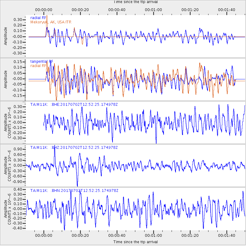
M11K Mekoryuk, AK, USA - Earthquake Result Viewer
*The percent match for this event was below the threshold and hence no stack was calculated.
| Earthquake location: |
Kermadec Islands Region |
| Earthquake latitude/longitude: |
-27.4/-176.1 |
| Earthquake time(UTC): |
2017/07/02 (183) 12:40:05 GMT |
| Earthquake Depth: |
10 km |
| Earthquake Magnitude: |
5.5 Mww |
| Earthquake Catalog/Contributor: |
NEIC PDE/us |
|
| Network: |
TA USArray Transportable Network (new EarthScope stations) |
| Station: |
M11K Mekoryuk, AK, USA |
| Lat/Lon: |
60.38 N/166.20 W |
| Elevation: |
3.0 m |
|
| Distance: |
87.9 deg |
| Az: |
4.894 deg |
| Baz: |
188.781 deg |
| Ray Param: |
$rayparam |
*The percent match for this event was below the threshold and hence was not used in the summary stack. |
|
| Radial Match: |
63.85668 % |
| Radial Bump: |
400 |
| Transverse Match: |
59.8333 % |
| Transverse Bump: |
400 |
| SOD ConfigId: |
13570011 |
| Insert Time: |
2019-04-28 08:03:27.684 +0000 |
| GWidth: |
2.5 |
| Max Bumps: |
400 |
| Tol: |
0.001 |
|
Signal To Noise
| Channel | StoN | STA | LTA |
| TA:M11K: :BHZ:20170702T12:52:25.174978Z | 1.1180543 | 1.08773115E-7 | 9.728787E-8 |
| TA:M11K: :BHN:20170702T12:52:25.174978Z | 0.935795 | 1.0843705E-7 | 1.1587692E-7 |
| TA:M11K: :BHE:20170702T12:52:25.174978Z | 0.51158845 | 5.9415733E-8 | 1.1613971E-7 |
| Arrivals |
| Ps | |
| PpPs | |
| PsPs/PpSs | |


