You are here: Home > Network List > TA - USArray Transportable Network (new EarthScope stations) Stations List
> Station A05A Maple Falls, WA, USA > Earthquake Result Viewer
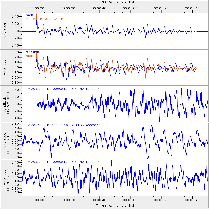
A05A Maple Falls, WA, USA - Earthquake Result Viewer
*The percent match for this event was below the threshold and hence no stack was calculated.
| Earthquake location: |
Tonga Islands |
| Earthquake latitude/longitude: |
-15.1/-173.5 |
| Earthquake time(UTC): |
2008/08/19 (232) 16:30:13 GMT |
| Earthquake Depth: |
8.0 km |
| Earthquake Magnitude: |
5.6 MB, 5.9 MS, 6.1 MW, 6.0 MW |
| Earthquake Catalog/Contributor: |
WHDF/NEIC |
|
| Network: |
TA USArray Transportable Network (new EarthScope stations) |
| Station: |
A05A Maple Falls, WA, USA |
| Lat/Lon: |
49.00 N/122.09 W |
| Elevation: |
174 m |
|
| Distance: |
78.3 deg |
| Az: |
31.702 deg |
| Baz: |
230.423 deg |
| Ray Param: |
$rayparam |
*The percent match for this event was below the threshold and hence was not used in the summary stack. |
|
| Radial Match: |
74.687614 % |
| Radial Bump: |
400 |
| Transverse Match: |
61.992382 % |
| Transverse Bump: |
400 |
| SOD ConfigId: |
2504 |
| Insert Time: |
2010-03-06 01:35:28.263 +0000 |
| GWidth: |
2.5 |
| Max Bumps: |
400 |
| Tol: |
0.001 |
|
Signal To Noise
| Channel | StoN | STA | LTA |
| TA:A05A: :BHN:20080819T16:41:42.400002Z | 3.4000237 | 3.0719204E-7 | 9.0349964E-8 |
| TA:A05A: :BHE:20080819T16:41:42.400002Z | 1.0765492 | 1.2968215E-7 | 1.2046095E-7 |
| TA:A05A: :BHZ:20080819T16:41:42.400002Z | 0.8557873 | 7.7397466E-8 | 9.0440075E-8 |
| Arrivals |
| Ps | |
| PpPs | |
| PsPs/PpSs | |


