You are here: Home > Network List > TA - USArray Transportable Network (new EarthScope stations) Stations List
> Station A05A Maple Falls, WA, USA > Earthquake Result Viewer
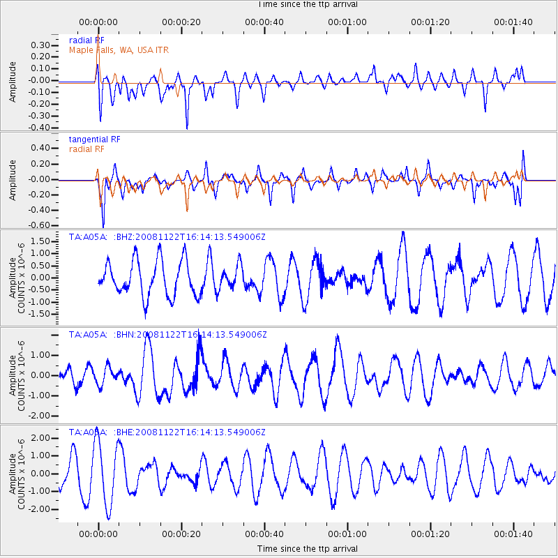
A05A Maple Falls, WA, USA - Earthquake Result Viewer
*The percent match for this event was below the threshold and hence no stack was calculated.
| Earthquake location: |
Southeast Of Loyalty Islands |
| Earthquake latitude/longitude: |
-22.5/171.2 |
| Earthquake time(UTC): |
2008/11/22 (327) 16:01:39 GMT |
| Earthquake Depth: |
57 km |
| Earthquake Magnitude: |
5.7 MB, 6.4 MW, 6.4 MW |
| Earthquake Catalog/Contributor: |
WHDF/NEIC |
|
| Network: |
TA USArray Transportable Network (new EarthScope stations) |
| Station: |
A05A Maple Falls, WA, USA |
| Lat/Lon: |
49.00 N/122.09 W |
| Elevation: |
174 m |
|
| Distance: |
92.6 deg |
| Az: |
37.271 deg |
| Baz: |
238.236 deg |
| Ray Param: |
$rayparam |
*The percent match for this event was below the threshold and hence was not used in the summary stack. |
|
| Radial Match: |
55.0333 % |
| Radial Bump: |
400 |
| Transverse Match: |
61.945526 % |
| Transverse Bump: |
376 |
| SOD ConfigId: |
2658 |
| Insert Time: |
2010-03-06 01:35:42.323 +0000 |
| GWidth: |
2.5 |
| Max Bumps: |
400 |
| Tol: |
0.001 |
|
Signal To Noise
| Channel | StoN | STA | LTA |
| TA:A05A: :BHN:20081122T16:14:13.549006Z | 1.0578527 | 4.207019E-7 | 3.9769418E-7 |
| TA:A05A: :BHE:20081122T16:14:13.549006Z | 3.5496511 | 1.7978276E-6 | 5.064801E-7 |
| TA:A05A: :BHZ:20081122T16:14:13.549006Z | 0.6348338 | 4.5187954E-7 | 7.118076E-7 |
| Arrivals |
| Ps | |
| PpPs | |
| PsPs/PpSs | |


