You are here: Home > Network List > LD - Lamont-Doherty Cooperative Seismographic Network Stations List
> Station GEDE Greenville, DE, USA > Earthquake Result Viewer
GEDE Greenville, DE, USA - Earthquake Result Viewer
| Earthquake location: |
Off Coast Of Central Chile |
| Earthquake latitude/longitude: |
-35.5/-73.4 |
| Earthquake time(UTC): |
2017/07/04 (185) 16:05:58 GMT |
| Earthquake Depth: |
10 km |
| Earthquake Magnitude: |
5.9 Mww |
| Earthquake Catalog/Contributor: |
NEIC PDE/us |
|
| Network: |
LD Lamont-Doherty Cooperative Seismographic Network |
| Station: |
GEDE Greenville, DE, USA |
| Lat/Lon: |
39.81 N/75.64 W |
| Elevation: |
105 m |
|
| Distance: |
75.0 deg |
| Az: |
358.197 deg |
| Baz: |
178.09 deg |
| Ray Param: |
0.051953364 |
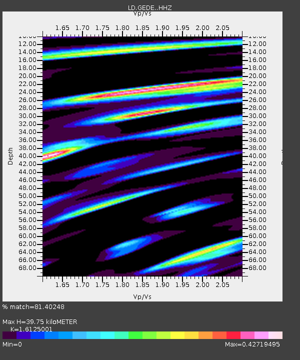
| Estimated Moho Depth: |
39.75 km |
| Estimated Crust Vp/Vs: |
1.61 |
| Assumed Crust Vp: |
6.287 km/s |
| Estimated Crust Vs: |
3.899 km/s |
| Estimated Crust Poisson's Ratio: |
0.19 |
|
| Radial Match: |
81.40248 % |
| Radial Bump: |
400 |
| Transverse Match: |
58.53754 % |
| Transverse Bump: |
400 |
| SOD ConfigId: |
13570011 |
| Insert Time: |
2019-04-28 08:07:42.376 +0000 |
| GWidth: |
2.5 |
| Max Bumps: |
400 |
| Tol: |
0.001 |
|
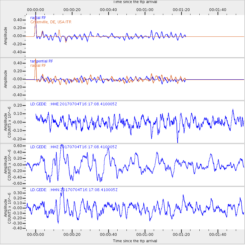
Signal To Noise
| Channel | StoN | STA | LTA |
| LD:GEDE: :HHZ:20170704T16:17:08.410005Z | 2.4368353 | 1.515966E-7 | 6.221045E-8 |
| LD:GEDE: :HHN:20170704T16:17:08.410005Z | 1.5290469 | 7.47197E-8 | 4.886685E-8 |
| LD:GEDE: :HHE:20170704T16:17:08.410005Z | 1.0804138 | 4.908969E-8 | 4.5436007E-8 |
| Arrivals |
| Ps | 4.0 SECOND |
| PpPs | 16 SECOND |
| PsPs/PpSs | 20 SECOND |


