You are here: Home > Network List > US - United States National Seismic Network Stations List
> Station WRAK Wrangell Island, Southeastern Alaska, Alaska, USA > Earthquake Result Viewer
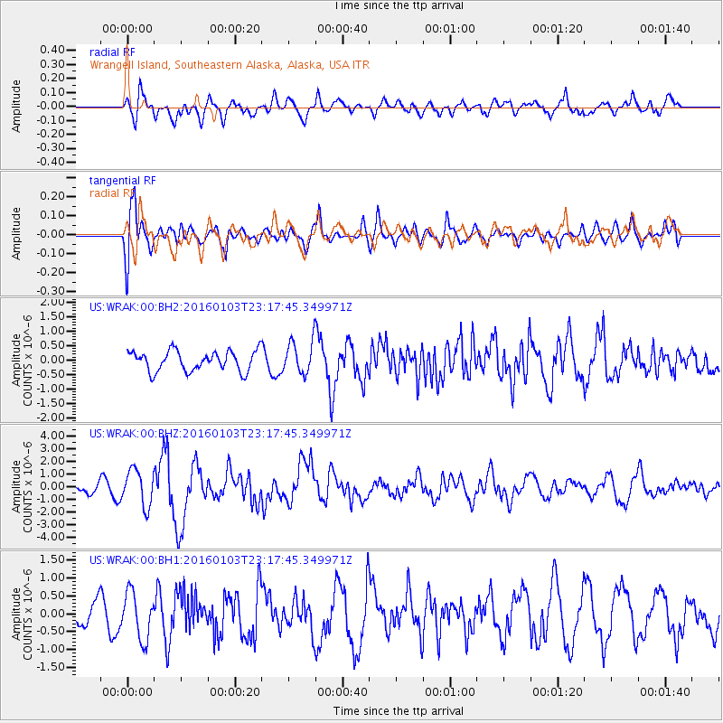
WRAK Wrangell Island, Southeastern Alaska, Alaska, USA - Earthquake Result Viewer
*The percent match for this event was below the threshold and hence no stack was calculated.
| Earthquake location: |
Myanmar-India Border Region |
| Earthquake latitude/longitude: |
24.8/93.7 |
| Earthquake time(UTC): |
2016/01/03 (003) 23:05:22 GMT |
| Earthquake Depth: |
55 km |
| Earthquake Magnitude: |
6.7 MWW, 6.6 MWB |
| Earthquake Catalog/Contributor: |
NEIC PDE/NEIC COMCAT |
|
| Network: |
US United States National Seismic Network |
| Station: |
WRAK Wrangell Island, Southeastern Alaska, Alaska, USA |
| Lat/Lon: |
56.42 N/132.35 W |
| Elevation: |
81 m |
|
| Distance: |
90.2 deg |
| Az: |
23.563 deg |
| Baz: |
319.185 deg |
| Ray Param: |
$rayparam |
*The percent match for this event was below the threshold and hence was not used in the summary stack. |
|
| Radial Match: |
71.24576 % |
| Radial Bump: |
400 |
| Transverse Match: |
72.16572 % |
| Transverse Bump: |
400 |
| SOD ConfigId: |
1379111 |
| Insert Time: |
2016-01-17 23:17:24.976 +0000 |
| GWidth: |
2.5 |
| Max Bumps: |
400 |
| Tol: |
0.001 |
|
Signal To Noise
| Channel | StoN | STA | LTA |
| US:WRAK:00:BHZ:20160103T23:17:45.349971Z | 3.4867768 | 1.4400057E-6 | 4.129905E-7 |
| US:WRAK:00:BH1:20160103T23:17:45.349971Z | 1.502981 | 6.6503276E-7 | 4.4247585E-7 |
| US:WRAK:00:BH2:20160103T23:17:45.349971Z | 1.6705227 | 5.7718853E-7 | 3.455137E-7 |
| Arrivals |
| Ps | |
| PpPs | |
| PsPs/PpSs | |


