You are here: Home > Network List > TA - USArray Transportable Network (new EarthScope stations) Stations List
> Station L44A Lake County Forest Preserve, Grayslake, IL, USA > Earthquake Result Viewer
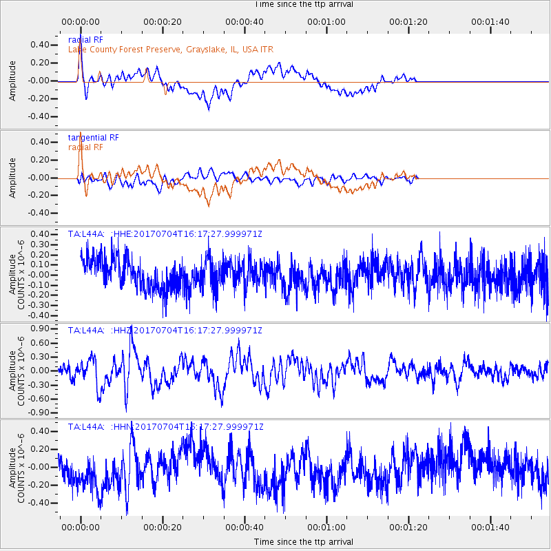
L44A Lake County Forest Preserve, Grayslake, IL, USA - Earthquake Result Viewer
*The percent match for this event was below the threshold and hence no stack was calculated.
| Earthquake location: |
Off Coast Of Central Chile |
| Earthquake latitude/longitude: |
-35.5/-73.4 |
| Earthquake time(UTC): |
2017/07/04 (185) 16:05:58 GMT |
| Earthquake Depth: |
10 km |
| Earthquake Magnitude: |
5.9 Mww |
| Earthquake Catalog/Contributor: |
NEIC PDE/us |
|
| Network: |
TA USArray Transportable Network (new EarthScope stations) |
| Station: |
L44A Lake County Forest Preserve, Grayslake, IL, USA |
| Lat/Lon: |
42.18 N/87.91 W |
| Elevation: |
202 m |
|
| Distance: |
78.5 deg |
| Az: |
349.023 deg |
| Baz: |
167.94 deg |
| Ray Param: |
$rayparam |
*The percent match for this event was below the threshold and hence was not used in the summary stack. |
|
| Radial Match: |
51.561825 % |
| Radial Bump: |
400 |
| Transverse Match: |
48.147038 % |
| Transverse Bump: |
400 |
| SOD ConfigId: |
13570011 |
| Insert Time: |
2019-04-28 08:11:20.361 +0000 |
| GWidth: |
2.5 |
| Max Bumps: |
400 |
| Tol: |
0.001 |
|
Signal To Noise
| Channel | StoN | STA | LTA |
| TA:L44A: :HHZ:20170704T16:17:27.999971Z | 3.0960534 | 2.9545038E-7 | 9.5428064E-8 |
| TA:L44A: :HHN:20170704T16:17:27.999971Z | 1.1909463 | 2.1039274E-7 | 1.7666012E-7 |
| TA:L44A: :HHE:20170704T16:17:27.999971Z | 1.033594 | 1.5264604E-7 | 1.476847E-7 |
| Arrivals |
| Ps | |
| PpPs | |
| PsPs/PpSs | |


