You are here: Home > Network List > CN - Canadian National Seismograph Network Stations List
> Station GGN SAINT GEORGE, NB > Earthquake Result Viewer
GGN SAINT GEORGE, NB - Earthquake Result Viewer
| Earthquake location: |
Montana |
| Earthquake latitude/longitude: |
46.9/-112.6 |
| Earthquake time(UTC): |
2017/07/06 (187) 06:30:16 GMT |
| Earthquake Depth: |
4.3 km |
| Earthquake Magnitude: |
5.8 Mww |
| Earthquake Catalog/Contributor: |
NEIC PDE/us |
|
| Network: |
CN Canadian National Seismograph Network |
| Station: |
GGN SAINT GEORGE, NB |
| Lat/Lon: |
45.12 N/66.82 W |
| Elevation: |
30 m |
|
| Distance: |
31.5 deg |
| Az: |
76.187 deg |
| Baz: |
289.868 deg |
| Ray Param: |
0.07906178 |
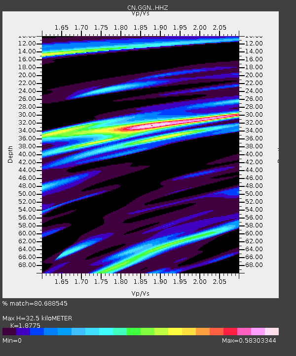
| Estimated Moho Depth: |
32.5 km |
| Estimated Crust Vp/Vs: |
1.88 |
| Assumed Crust Vp: |
6.419 km/s |
| Estimated Crust Vs: |
3.419 km/s |
| Estimated Crust Poisson's Ratio: |
0.30 |
|
| Radial Match: |
80.688545 % |
| Radial Bump: |
253 |
| Transverse Match: |
66.19536 % |
| Transverse Bump: |
400 |
| SOD ConfigId: |
13570011 |
| Insert Time: |
2019-04-28 08:13:34.881 +0000 |
| GWidth: |
2.5 |
| Max Bumps: |
400 |
| Tol: |
0.001 |
|

Signal To Noise
| Channel | StoN | STA | LTA |
| CN:GGN: :HHZ:20170706T06:36:07.720011Z | 4.887153 | 5.595322E-7 | 1.14490426E-7 |
| CN:GGN: :HHN:20170706T06:36:07.720011Z | 1.6791718 | 1.5957251E-7 | 9.503048E-8 |
| CN:GGN: :HHE:20170706T06:36:07.720011Z | 1.9644635 | 2.0727471E-7 | 1.0551212E-7 |
| Arrivals |
| Ps | 4.8 SECOND |
| PpPs | 14 SECOND |
| PsPs/PpSs | 18 SECOND |


