You are here: Home > Network List > TA - USArray Transportable Network (new EarthScope stations) Stations List
> Station E08A Dider Farm, Eltopia, WA, USA > Earthquake Result Viewer
E08A Dider Farm, Eltopia, WA, USA - Earthquake Result Viewer
| Earthquake location: |
Lake Baykal Region, Russia |
| Earthquake latitude/longitude: |
51.6/104.2 |
| Earthquake time(UTC): |
2008/08/27 (240) 01:35:32 GMT |
| Earthquake Depth: |
16 km |
| Earthquake Magnitude: |
5.8 MB, 6.2 MS, 6.2 MW, 6.2 MW |
| Earthquake Catalog/Contributor: |
WHDF/NEIC |
|
| Network: |
TA USArray Transportable Network (new EarthScope stations) |
| Station: |
E08A Dider Farm, Eltopia, WA, USA |
| Lat/Lon: |
46.49 N/119.06 W |
| Elevation: |
233 m |
|
| Distance: |
75.5 deg |
| Az: |
29.26 deg |
| Baz: |
333.821 deg |
| Ray Param: |
0.05164734 |
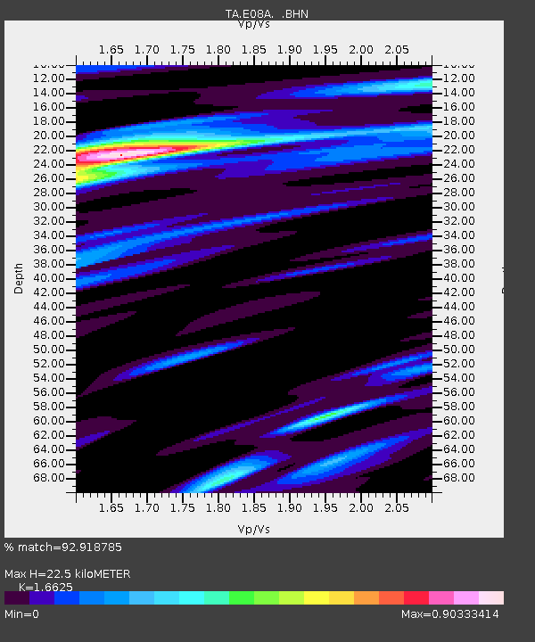
| Estimated Moho Depth: |
22.5 km |
| Estimated Crust Vp/Vs: |
1.66 |
| Assumed Crust Vp: |
6.419 km/s |
| Estimated Crust Vs: |
3.861 km/s |
| Estimated Crust Poisson's Ratio: |
0.22 |
|
| Radial Match: |
92.918785 % |
| Radial Bump: |
400 |
| Transverse Match: |
72.29816 % |
| Transverse Bump: |
400 |
| SOD ConfigId: |
2504 |
| Insert Time: |
2010-03-06 01:37:13.766 +0000 |
| GWidth: |
2.5 |
| Max Bumps: |
400 |
| Tol: |
0.001 |
|
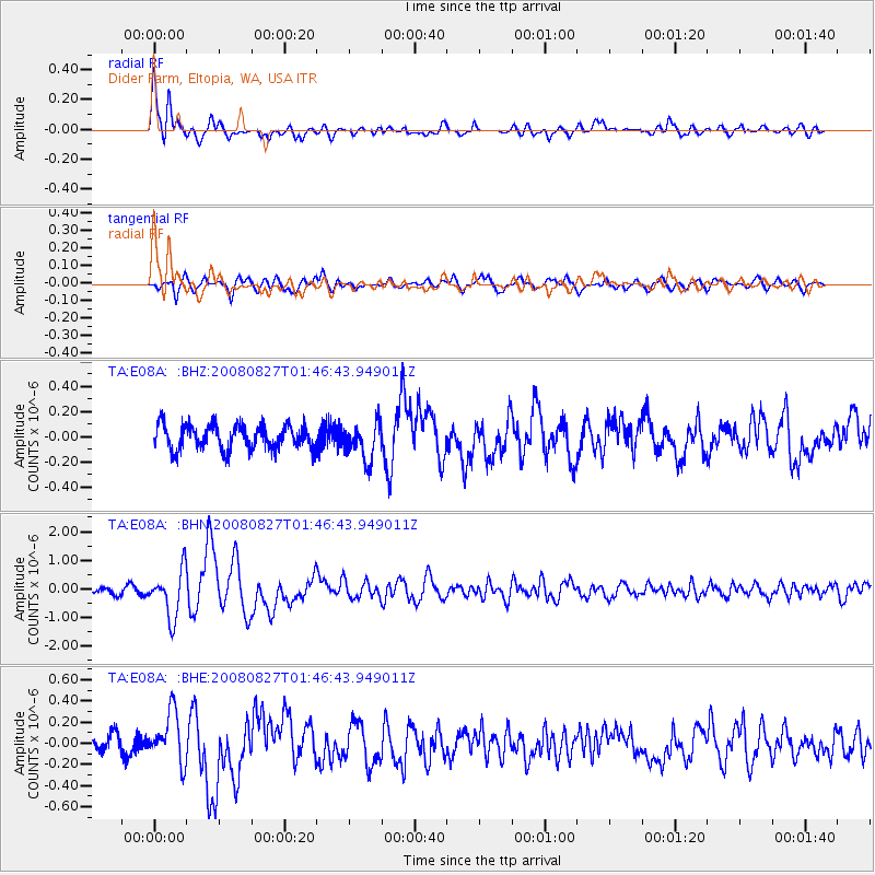
Signal To Noise
| Channel | StoN | STA | LTA |
| TA:E08A: :BHN:20080827T01:46:43.949011Z | 8.798438 | 8.141758E-7 | 9.25364E-8 |
| TA:E08A: :BHE:20080827T01:46:43.949011Z | 3.2367396 | 2.3616751E-7 | 7.296463E-8 |
| TA:E08A: :BHZ:20080827T01:46:43.949011Z | 1.5226133 | 1.4818619E-7 | 9.7323586E-8 |
| Arrivals |
| Ps | 2.4 SECOND |
| PpPs | 9.0 SECOND |
| PsPs/PpSs | 11 SECOND |


