You are here: Home > Network List > TA - USArray Transportable Network (new EarthScope stations) Stations List
> Station E08A Dider Farm, Eltopia, WA, USA > Earthquake Result Viewer
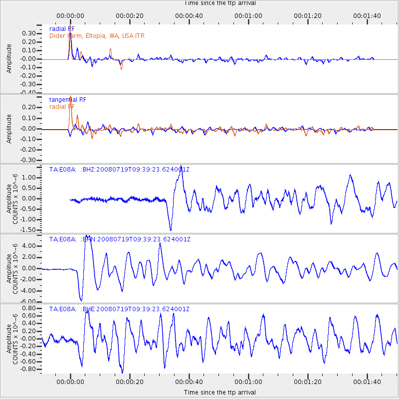
E08A Dider Farm, Eltopia, WA, USA - Earthquake Result Viewer
| Earthquake location: |
Santa Cruz Islands Region |
| Earthquake latitude/longitude: |
-11.0/164.5 |
| Earthquake time(UTC): |
2008/07/19 (201) 09:27:01 GMT |
| Earthquake Depth: |
11 km |
| Earthquake Magnitude: |
6.1 MB, 6.4 MS, 6.6 MW, 6.6 MW |
| Earthquake Catalog/Contributor: |
WHDF/NEIC |
|
| Network: |
TA USArray Transportable Network (new EarthScope stations) |
| Station: |
E08A Dider Farm, Eltopia, WA, USA |
| Lat/Lon: |
46.49 N/119.06 W |
| Elevation: |
233 m |
|
| Distance: |
88.8 deg |
| Az: |
42.207 deg |
| Baz: |
252.672 deg |
| Ray Param: |
0.04233369 |
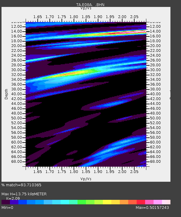
| Estimated Moho Depth: |
13.75 km |
| Estimated Crust Vp/Vs: |
2.09 |
| Assumed Crust Vp: |
6.419 km/s |
| Estimated Crust Vs: |
3.071 km/s |
| Estimated Crust Poisson's Ratio: |
0.35 |
|
| Radial Match: |
93.710365 % |
| Radial Bump: |
361 |
| Transverse Match: |
86.72187 % |
| Transverse Bump: |
316 |
| SOD ConfigId: |
2658 |
| Insert Time: |
2010-03-06 01:37:21.019 +0000 |
| GWidth: |
2.5 |
| Max Bumps: |
400 |
| Tol: |
0.001 |
|
Signal To Noise
| Channel | StoN | STA | LTA |
| TA:E08A: :BHN:20080719T09:39:23.624001Z | 59.269577 | 2.554117E-6 | 4.3093223E-8 |
| TA:E08A: :BHE:20080719T09:39:23.624001Z | 3.1476166 | 2.8418455E-7 | 9.028563E-8 |
| TA:E08A: :BHZ:20080719T09:39:23.624001Z | 11.050789 | 6.1107914E-7 | 5.529733E-8 |
| Arrivals |
| Ps | 2.4 SECOND |
| PpPs | 6.5 SECOND |
| PsPs/PpSs | 8.9 SECOND |


