You are here: Home > Network List > TA - USArray Transportable Network (new EarthScope stations) Stations List
> Station E08A Dider Farm, Eltopia, WA, USA > Earthquake Result Viewer
E08A Dider Farm, Eltopia, WA, USA - Earthquake Result Viewer
| Earthquake location: |
Andreanof Islands, Aleutian Is. |
| Earthquake latitude/longitude: |
51.4/-179.0 |
| Earthquake time(UTC): |
2007/12/21 (355) 07:24:34 GMT |
| Earthquake Depth: |
30 km |
| Earthquake Magnitude: |
6.1 MB, 6.2 MW, 6.3 ML |
| Earthquake Catalog/Contributor: |
WHDF/NEIC |
|
| Network: |
TA USArray Transportable Network (new EarthScope stations) |
| Station: |
E08A Dider Farm, Eltopia, WA, USA |
| Lat/Lon: |
46.49 N/119.06 W |
| Elevation: |
233 m |
|
| Distance: |
38.7 deg |
| Az: |
72.937 deg |
| Baz: |
299.823 deg |
| Ray Param: |
0.07535084 |
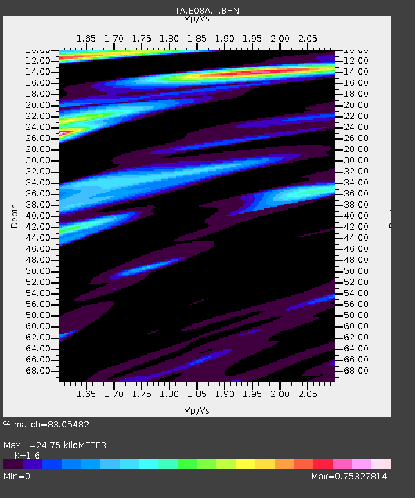
| Estimated Moho Depth: |
24.75 km |
| Estimated Crust Vp/Vs: |
1.60 |
| Assumed Crust Vp: |
6.419 km/s |
| Estimated Crust Vs: |
4.012 km/s |
| Estimated Crust Poisson's Ratio: |
0.18 |
|
| Radial Match: |
83.05482 % |
| Radial Bump: |
400 |
| Transverse Match: |
76.861465 % |
| Transverse Bump: |
400 |
| SOD ConfigId: |
2564 |
| Insert Time: |
2010-03-06 01:37:22.525 +0000 |
| GWidth: |
2.5 |
| Max Bumps: |
400 |
| Tol: |
0.001 |
|
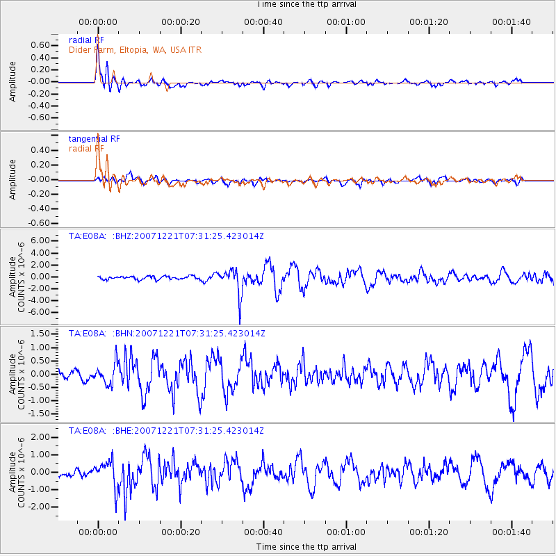
Signal To Noise
| Channel | StoN | STA | LTA |
| TA:E08A: :BHN:20071221T07:31:25.423014Z | 1.3796191 | 4.011668E-7 | 2.9078083E-7 |
| TA:E08A: :BHE:20071221T07:31:25.423014Z | 2.5870504 | 7.4596375E-7 | 2.8834526E-7 |
| TA:E08A: :BHZ:20071221T07:31:25.423014Z | 8.466272 | 2.2609865E-6 | 2.6705808E-7 |
| Arrivals |
| Ps | 2.5 SECOND |
| PpPs | 9.3 SECOND |
| PsPs/PpSs | 12 SECOND |


