You are here: Home > Network List > TA - USArray Transportable Network (new EarthScope stations) Stations List
> Station I17K Unalakleet, AK, USA > Earthquake Result Viewer
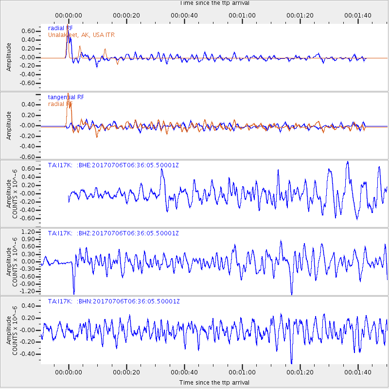
I17K Unalakleet, AK, USA - Earthquake Result Viewer
*The percent match for this event was below the threshold and hence no stack was calculated.
| Earthquake location: |
Montana |
| Earthquake latitude/longitude: |
46.9/-112.6 |
| Earthquake time(UTC): |
2017/07/06 (187) 06:30:16 GMT |
| Earthquake Depth: |
4.3 km |
| Earthquake Magnitude: |
5.8 Mww |
| Earthquake Catalog/Contributor: |
NEIC PDE/us |
|
| Network: |
TA USArray Transportable Network (new EarthScope stations) |
| Station: |
I17K Unalakleet, AK, USA |
| Lat/Lon: |
63.89 N/160.70 W |
| Elevation: |
105 m |
|
| Distance: |
31.2 deg |
| Az: |
320.515 deg |
| Baz: |
99.835 deg |
| Ray Param: |
$rayparam |
*The percent match for this event was below the threshold and hence was not used in the summary stack. |
|
| Radial Match: |
76.51951 % |
| Radial Bump: |
400 |
| Transverse Match: |
59.417713 % |
| Transverse Bump: |
400 |
| SOD ConfigId: |
13570011 |
| Insert Time: |
2019-04-28 08:16:07.797 +0000 |
| GWidth: |
2.5 |
| Max Bumps: |
400 |
| Tol: |
0.001 |
|
Signal To Noise
| Channel | StoN | STA | LTA |
| TA:I17K: :BHZ:20170706T06:36:05.50001Z | 4.772462 | 4.051887E-7 | 8.49014E-8 |
| TA:I17K: :BHN:20170706T06:36:05.50001Z | 0.92208135 | 7.255472E-8 | 7.868581E-8 |
| TA:I17K: :BHE:20170706T06:36:05.50001Z | 3.3100972 | 2.80587E-7 | 8.4767E-8 |
| Arrivals |
| Ps | |
| PpPs | |
| PsPs/PpSs | |


