You are here: Home > Network List > TA - USArray Transportable Network (new EarthScope stations) Stations List
> Station E08A Dider Farm, Eltopia, WA, USA > Earthquake Result Viewer
E08A Dider Farm, Eltopia, WA, USA - Earthquake Result Viewer
| Earthquake location: |
Sea Of Okhotsk |
| Earthquake latitude/longitude: |
54.2/154.3 |
| Earthquake time(UTC): |
2008/11/24 (329) 09:02:58 GMT |
| Earthquake Depth: |
492 km |
| Earthquake Magnitude: |
6.5 MB, 7.3 MW, 7.3 MW |
| Earthquake Catalog/Contributor: |
WHDF/NEIC |
|
| Network: |
TA USArray Transportable Network (new EarthScope stations) |
| Station: |
E08A Dider Farm, Eltopia, WA, USA |
| Lat/Lon: |
46.49 N/119.06 W |
| Elevation: |
233 m |
|
| Distance: |
52.5 deg |
| Az: |
60.403 deg |
| Baz: |
312.321 deg |
| Ray Param: |
0.06463434 |
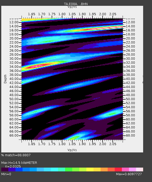
| Estimated Moho Depth: |
14.5 km |
| Estimated Crust Vp/Vs: |
2.03 |
| Assumed Crust Vp: |
6.419 km/s |
| Estimated Crust Vs: |
3.158 km/s |
| Estimated Crust Poisson's Ratio: |
0.34 |
|
| Radial Match: |
88.8807 % |
| Radial Bump: |
400 |
| Transverse Match: |
75.28358 % |
| Transverse Bump: |
400 |
| SOD ConfigId: |
2658 |
| Insert Time: |
2010-03-06 01:38:03.751 +0000 |
| GWidth: |
2.5 |
| Max Bumps: |
400 |
| Tol: |
0.001 |
|
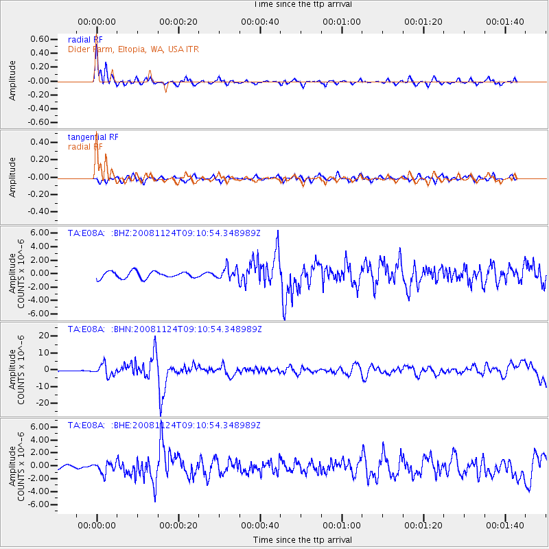
Signal To Noise
| Channel | StoN | STA | LTA |
| TA:E08A: :BHN:20081124T09:10:54.348989Z | 9.732784 | 3.3562228E-6 | 3.4483688E-7 |
| TA:E08A: :BHE:20081124T09:10:54.348989Z | 2.099149 | 8.4858306E-7 | 4.0425095E-7 |
| TA:E08A: :BHZ:20081124T09:10:54.348989Z | 1.7961069 | 8.854312E-7 | 4.9297245E-7 |
| Arrivals |
| Ps | 2.4 SECOND |
| PpPs | 6.5 SECOND |
| PsPs/PpSs | 9.0 SECOND |


