You are here: Home > Network List > TA - USArray Transportable Network (new EarthScope stations) Stations List
> Station E08A Dider Farm, Eltopia, WA, USA > Earthquake Result Viewer
E08A Dider Farm, Eltopia, WA, USA - Earthquake Result Viewer
| Earthquake location: |
Kuril Islands |
| Earthquake latitude/longitude: |
46.6/153.3 |
| Earthquake time(UTC): |
2006/11/15 (319) 11:14:13 GMT |
| Earthquake Depth: |
10 km |
| Earthquake Magnitude: |
6.5 MB, 7.8 MS, 8.3 MW, 7.9 MW |
| Earthquake Catalog/Contributor: |
WHDF/NEIC |
|
| Network: |
TA USArray Transportable Network (new EarthScope stations) |
| Station: |
E08A Dider Farm, Eltopia, WA, USA |
| Lat/Lon: |
46.49 N/119.06 W |
| Elevation: |
233 m |
|
| Distance: |
57.1 deg |
| Az: |
55.286 deg |
| Baz: |
304.867 deg |
| Ray Param: |
0.06369421 |
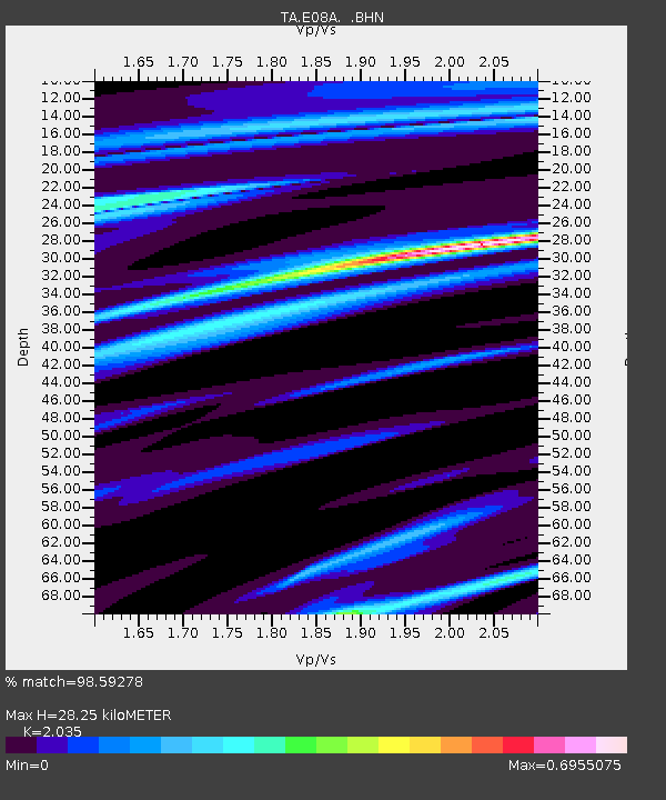
| Estimated Moho Depth: |
28.25 km |
| Estimated Crust Vp/Vs: |
2.04 |
| Assumed Crust Vp: |
6.419 km/s |
| Estimated Crust Vs: |
3.154 km/s |
| Estimated Crust Poisson's Ratio: |
0.34 |
|
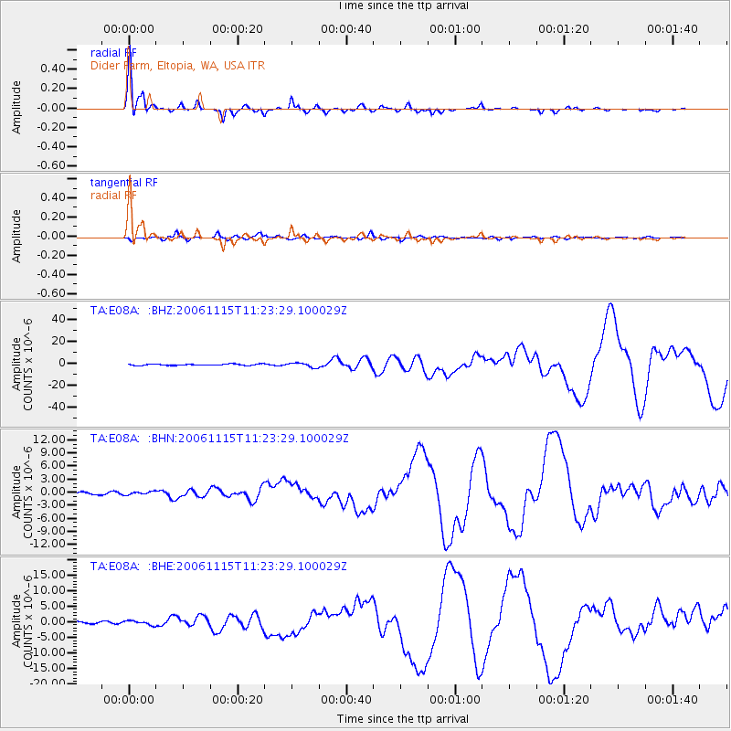
| Radial Match: |
98.59278 % |
| Radial Bump: |
312 |
| Transverse Match: |
86.99164 % |
| Transverse Bump: |
400 |
| SOD ConfigId: |
2564 |
| Insert Time: |
2010-03-06 01:38:07.303 +0000 |
| GWidth: |
2.5 |
| Max Bumps: |
400 |
| Tol: |
0.001 |
|
Signal To Noise
| Channel | StoN | STA | LTA |
| TA:E08A: :BHN:20061115T11:23:29.100029Z | 0.883807 | 3.450555E-7 | 3.904195E-7 |
| TA:E08A: :BHE:20061115T11:23:29.100029Z | 1.5159081 | 6.6445494E-7 | 4.3832136E-7 |
| TA:E08A: :BHZ:20061115T11:23:29.100029Z | 3.3629737 | 2.0158498E-6 | 5.9942477E-7 |
| Arrivals |
| Ps | 4.8 SECOND |
| PpPs | 13 SECOND |
| PsPs/PpSs | 18 SECOND |


