You are here: Home > Network List > TA - USArray Transportable Network (new EarthScope stations) Stations List
> Station E08A Dider Farm, Eltopia, WA, USA > Earthquake Result Viewer
E08A Dider Farm, Eltopia, WA, USA - Earthquake Result Viewer
| Earthquake location: |
Kuril Islands |
| Earthquake latitude/longitude: |
46.3/153.3 |
| Earthquake time(UTC): |
2006/10/13 (286) 13:47:39 GMT |
| Earthquake Depth: |
8.0 km |
| Earthquake Magnitude: |
5.5 MB, 5.8 MS, 6.3 MW, 5.8 MW |
| Earthquake Catalog/Contributor: |
WHDF/NEIC |
|
| Network: |
TA USArray Transportable Network (new EarthScope stations) |
| Station: |
E08A Dider Farm, Eltopia, WA, USA |
| Lat/Lon: |
46.49 N/119.06 W |
| Elevation: |
233 m |
|
| Distance: |
57.3 deg |
| Az: |
55.112 deg |
| Baz: |
304.528 deg |
| Ray Param: |
0.0635786 |
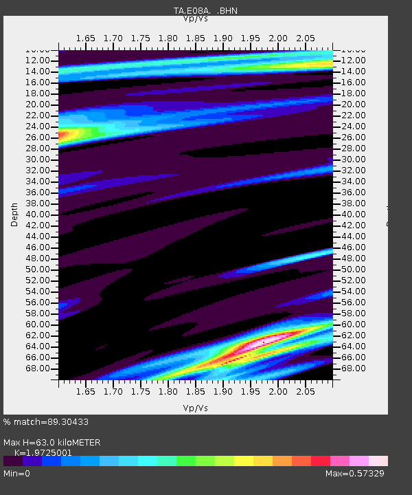
| Estimated Moho Depth: |
63.0 km |
| Estimated Crust Vp/Vs: |
1.97 |
| Assumed Crust Vp: |
6.419 km/s |
| Estimated Crust Vs: |
3.254 km/s |
| Estimated Crust Poisson's Ratio: |
0.33 |
|
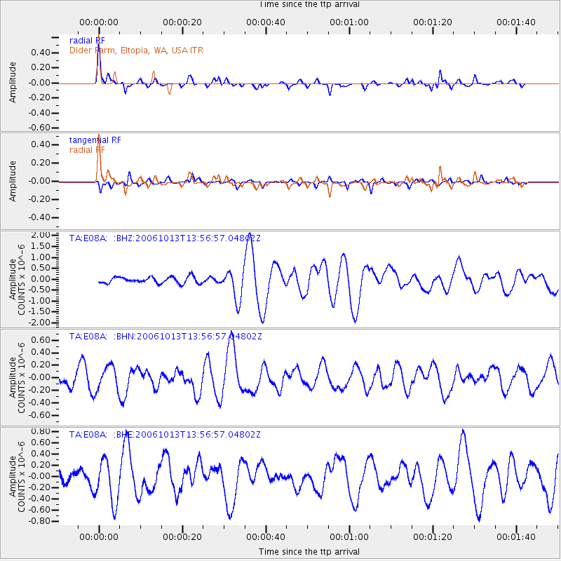
| Radial Match: |
89.30433 % |
| Radial Bump: |
313 |
| Transverse Match: |
64.89877 % |
| Transverse Bump: |
400 |
| SOD ConfigId: |
2564 |
| Insert Time: |
2010-03-06 01:38:11.892 +0000 |
| GWidth: |
2.5 |
| Max Bumps: |
400 |
| Tol: |
0.001 |
|
Signal To Noise
| Channel | StoN | STA | LTA |
| TA:E08A: :BHN:20061013T13:56:57.04802Z | 1.611214 | 1.899934E-7 | 1.17919406E-7 |
| TA:E08A: :BHE:20061013T13:56:57.04802Z | 4.5285654 | 3.8187318E-7 | 8.4325414E-8 |
| TA:E08A: :BHZ:20061013T13:56:57.04802Z | 4.7888017 | 6.8872373E-7 | 1.4381963E-7 |
| Arrivals |
| Ps | 10.0 SECOND |
| PpPs | 28 SECOND |
| PsPs/PpSs | 38 SECOND |


