You are here: Home > Network List > AV - Alaska Volcano Observatory Stations List
> Station AMKA Regional Station, Amchitka Island, Alaska > Earthquake Result Viewer
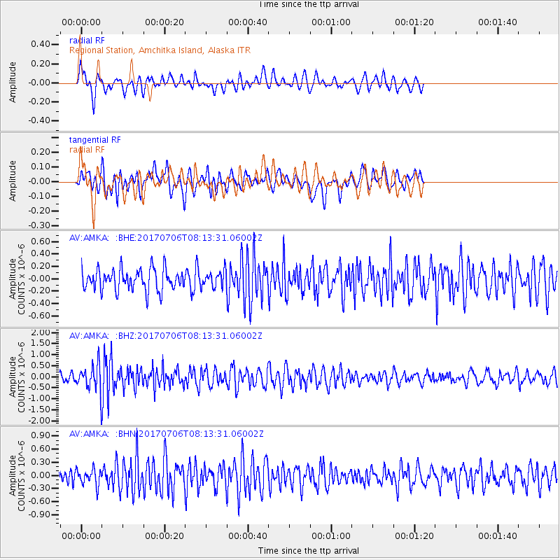
AMKA Regional Station, Amchitka Island, Alaska - Earthquake Result Viewer
*The percent match for this event was below the threshold and hence no stack was calculated.
| Earthquake location: |
Leyte, Philippines |
| Earthquake latitude/longitude: |
11.1/124.6 |
| Earthquake time(UTC): |
2017/07/06 (187) 08:03:57 GMT |
| Earthquake Depth: |
6.5 km |
| Earthquake Magnitude: |
6.5 mww |
| Earthquake Catalog/Contributor: |
NEIC PDE/us |
|
| Network: |
AV Alaska Volcano Observatory |
| Station: |
AMKA Regional Station, Amchitka Island, Alaska |
| Lat/Lon: |
51.38 N/179.30 E |
| Elevation: |
116 m |
|
| Distance: |
59.7 deg |
| Az: |
36.326 deg |
| Baz: |
248.077 deg |
| Ray Param: |
$rayparam |
*The percent match for this event was below the threshold and hence was not used in the summary stack. |
|
| Radial Match: |
56.33268 % |
| Radial Bump: |
400 |
| Transverse Match: |
45.084686 % |
| Transverse Bump: |
388 |
| SOD ConfigId: |
13570011 |
| Insert Time: |
2019-04-28 08:18:25.758 +0000 |
| GWidth: |
2.5 |
| Max Bumps: |
400 |
| Tol: |
0.001 |
|
Signal To Noise
| Channel | StoN | STA | LTA |
| AV:AMKA: :BHZ:20170706T08:13:31.06002Z | 3.0486603 | 6.3452785E-7 | 2.0813334E-7 |
| AV:AMKA: :BHN:20170706T08:13:31.06002Z | 1.0504138 | 1.8281061E-7 | 1.7403674E-7 |
| AV:AMKA: :BHE:20170706T08:13:31.06002Z | 0.94442755 | 1.5834328E-7 | 1.676606E-7 |
| Arrivals |
| Ps | |
| PpPs | |
| PsPs/PpSs | |


