You are here: Home > Network List > AV - Alaska Volcano Observatory Stations List
> Station SPCR Ckakachatna River, Mount Spurr, Alaska > Earthquake Result Viewer
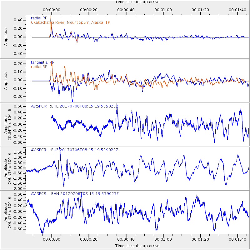
SPCR Ckakachatna River, Mount Spurr, Alaska - Earthquake Result Viewer
*The percent match for this event was below the threshold and hence no stack was calculated.
| Earthquake location: |
Leyte, Philippines |
| Earthquake latitude/longitude: |
11.1/124.6 |
| Earthquake time(UTC): |
2017/07/06 (187) 08:03:57 GMT |
| Earthquake Depth: |
6.5 km |
| Earthquake Magnitude: |
6.5 mww |
| Earthquake Catalog/Contributor: |
NEIC PDE/us |
|
| Network: |
AV Alaska Volcano Observatory |
| Station: |
SPCR Ckakachatna River, Mount Spurr, Alaska |
| Lat/Lon: |
61.20 N/152.21 W |
| Elevation: |
984 m |
|
| Distance: |
77.0 deg |
| Az: |
29.561 deg |
| Baz: |
269.437 deg |
| Ray Param: |
$rayparam |
*The percent match for this event was below the threshold and hence was not used in the summary stack. |
|
| Radial Match: |
76.1077 % |
| Radial Bump: |
400 |
| Transverse Match: |
47.48446 % |
| Transverse Bump: |
400 |
| SOD ConfigId: |
13570011 |
| Insert Time: |
2019-04-28 08:18:42.971 +0000 |
| GWidth: |
2.5 |
| Max Bumps: |
400 |
| Tol: |
0.001 |
|
Signal To Noise
| Channel | StoN | STA | LTA |
| AV:SPCR: :BHZ:20170706T08:15:19.539023Z | 5.771312 | 8.0103166E-7 | 1.3879541E-7 |
| AV:SPCR: :BHN:20170706T08:15:19.539023Z | 1.0013174 | 2.929826E-7 | 2.9259715E-7 |
| AV:SPCR: :BHE:20170706T08:15:19.539023Z | 1.7393488 | 1.9777966E-7 | 1.1370902E-7 |
| Arrivals |
| Ps | |
| PpPs | |
| PsPs/PpSs | |


