You are here: Home > Network List > TA - USArray Transportable Network (new EarthScope stations) Stations List
> Station E08A Dider Farm, Eltopia, WA, USA > Earthquake Result Viewer
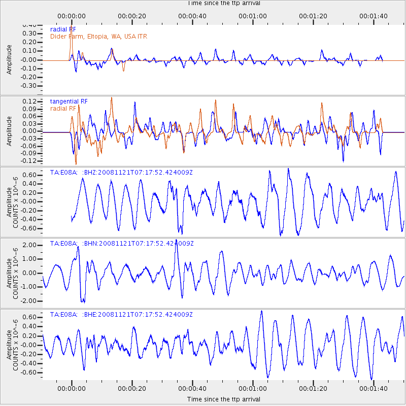
E08A Dider Farm, Eltopia, WA, USA - Earthquake Result Viewer
*The percent match for this event was below the threshold and hence no stack was calculated.
| Earthquake location: |
Solomon Islands |
| Earthquake latitude/longitude: |
-8.9/159.6 |
| Earthquake time(UTC): |
2008/11/21 (326) 07:05:34 GMT |
| Earthquake Depth: |
118 km |
| Earthquake Magnitude: |
6.0 MB, 6.1 MW, 6.0 MW |
| Earthquake Catalog/Contributor: |
WHDF/NEIC |
|
| Network: |
TA USArray Transportable Network (new EarthScope stations) |
| Station: |
E08A Dider Farm, Eltopia, WA, USA |
| Lat/Lon: |
46.49 N/119.06 W |
| Elevation: |
233 m |
|
| Distance: |
90.5 deg |
| Az: |
43.089 deg |
| Baz: |
257.66 deg |
| Ray Param: |
$rayparam |
*The percent match for this event was below the threshold and hence was not used in the summary stack. |
|
| Radial Match: |
51.748783 % |
| Radial Bump: |
374 |
| Transverse Match: |
60.90819 % |
| Transverse Bump: |
378 |
| SOD ConfigId: |
2658 |
| Insert Time: |
2010-03-06 01:38:52.247 +0000 |
| GWidth: |
2.5 |
| Max Bumps: |
400 |
| Tol: |
0.001 |
|
Signal To Noise
| Channel | StoN | STA | LTA |
| TA:E08A: :BHN:20081121T07:17:52.424009Z | 2.311381 | 1.3313577E-6 | 5.7600096E-7 |
| TA:E08A: :BHE:20081121T07:17:52.424009Z | 0.98712385 | 2.42921E-7 | 2.460897E-7 |
| TA:E08A: :BHZ:20081121T07:17:52.424009Z | 0.77671504 | 2.5292488E-7 | 3.256341E-7 |
| Arrivals |
| Ps | |
| PpPs | |
| PsPs/PpSs | |


