You are here: Home > Network List > TA - USArray Transportable Network (new EarthScope stations) Stations List
> Station F25K Christian River, AK, USA > Earthquake Result Viewer
F25K Christian River, AK, USA - Earthquake Result Viewer
| Earthquake location: |
Leyte, Philippines |
| Earthquake latitude/longitude: |
11.1/124.6 |
| Earthquake time(UTC): |
2017/07/06 (187) 08:03:57 GMT |
| Earthquake Depth: |
6.5 km |
| Earthquake Magnitude: |
6.5 mww |
| Earthquake Catalog/Contributor: |
NEIC PDE/us |
|
| Network: |
TA USArray Transportable Network (new EarthScope stations) |
| Station: |
F25K Christian River, AK, USA |
| Lat/Lon: |
67.59 N/145.64 W |
| Elevation: |
864 m |
|
| Distance: |
79.7 deg |
| Az: |
22.932 deg |
| Baz: |
274.024 deg |
| Ray Param: |
0.048783705 |
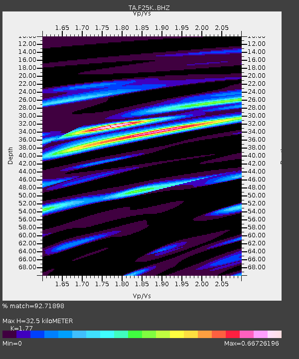
| Estimated Moho Depth: |
32.5 km |
| Estimated Crust Vp/Vs: |
1.77 |
| Assumed Crust Vp: |
6.522 km/s |
| Estimated Crust Vs: |
3.685 km/s |
| Estimated Crust Poisson's Ratio: |
0.27 |
|
| Radial Match: |
92.71898 % |
| Radial Bump: |
400 |
| Transverse Match: |
73.47951 % |
| Transverse Bump: |
400 |
| SOD ConfigId: |
13570011 |
| Insert Time: |
2019-04-28 08:21:14.995 +0000 |
| GWidth: |
2.5 |
| Max Bumps: |
400 |
| Tol: |
0.001 |
|

Signal To Noise
| Channel | StoN | STA | LTA |
| TA:F25K: :BHZ:20170706T08:15:34.199973Z | 3.3911247 | 2.721471E-7 | 8.0252754E-8 |
| TA:F25K: :BHN:20170706T08:15:34.199973Z | 0.9314057 | 4.484871E-8 | 4.8151637E-8 |
| TA:F25K: :BHE:20170706T08:15:34.199973Z | 2.6437201 | 1.14367474E-7 | 4.326005E-8 |
| Arrivals |
| Ps | 4.0 SECOND |
| PpPs | 13 SECOND |
| PsPs/PpSs | 17 SECOND |


