You are here: Home > Network List > TA - USArray Transportable Network (new EarthScope stations) Stations List
> Station H25L Birch Creek, AK, USA > Earthquake Result Viewer
H25L Birch Creek, AK, USA - Earthquake Result Viewer
| Earthquake location: |
Leyte, Philippines |
| Earthquake latitude/longitude: |
11.1/124.6 |
| Earthquake time(UTC): |
2017/07/06 (187) 08:03:57 GMT |
| Earthquake Depth: |
6.5 km |
| Earthquake Magnitude: |
6.5 mww |
| Earthquake Catalog/Contributor: |
NEIC PDE/us |
|
| Network: |
TA USArray Transportable Network (new EarthScope stations) |
| Station: |
H25L Birch Creek, AK, USA |
| Lat/Lon: |
66.27 N/145.82 W |
| Elevation: |
144 m |
|
| Distance: |
79.7 deg |
| Az: |
24.288 deg |
| Baz: |
274.105 deg |
| Ray Param: |
0.0487663 |
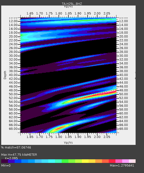
| Estimated Moho Depth: |
47.75 km |
| Estimated Crust Vp/Vs: |
2.10 |
| Assumed Crust Vp: |
6.522 km/s |
| Estimated Crust Vs: |
3.113 km/s |
| Estimated Crust Poisson's Ratio: |
0.35 |
|
| Radial Match: |
87.06746 % |
| Radial Bump: |
400 |
| Transverse Match: |
82.07404 % |
| Transverse Bump: |
400 |
| SOD ConfigId: |
13570011 |
| Insert Time: |
2019-04-28 08:21:31.408 +0000 |
| GWidth: |
2.5 |
| Max Bumps: |
400 |
| Tol: |
0.001 |
|

Signal To Noise
| Channel | StoN | STA | LTA |
| TA:H25L: :BHZ:20170706T08:15:34.349998Z | 4.114474 | 7.7789207E-7 | 1.8906233E-7 |
| TA:H25L: :BHN:20170706T08:15:34.349998Z | 0.5387396 | 1.5093265E-7 | 2.8015882E-7 |
| TA:H25L: :BHE:20170706T08:15:34.349998Z | 1.3747511 | 2.0810987E-7 | 1.5138004E-7 |
| Arrivals |
| Ps | 8.2 SECOND |
| PpPs | 22 SECOND |
| PsPs/PpSs | 30 SECOND |


