You are here: Home > Network List > TA - USArray Transportable Network (new EarthScope stations) Stations List
> Station I29M Ogilvie Camp, Yukon, CA > Earthquake Result Viewer
I29M Ogilvie Camp, Yukon, CA - Earthquake Result Viewer
| Earthquake location: |
Leyte, Philippines |
| Earthquake latitude/longitude: |
11.1/124.6 |
| Earthquake time(UTC): |
2017/07/06 (187) 08:03:57 GMT |
| Earthquake Depth: |
6.5 km |
| Earthquake Magnitude: |
6.5 mww |
| Earthquake Catalog/Contributor: |
NEIC PDE/us |
|
| Network: |
TA USArray Transportable Network (new EarthScope stations) |
| Station: |
I29M Ogilvie Camp, Yukon, CA |
| Lat/Lon: |
65.36 N/138.31 W |
| Elevation: |
602 m |
|
| Distance: |
82.9 deg |
| Az: |
24.787 deg |
| Baz: |
281.027 deg |
| Ray Param: |
0.04656062 |
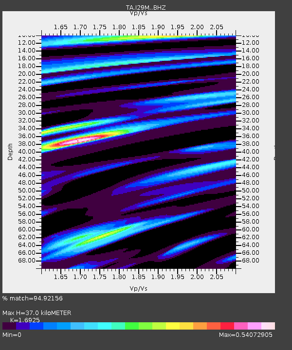
| Estimated Moho Depth: |
37.0 km |
| Estimated Crust Vp/Vs: |
1.69 |
| Assumed Crust Vp: |
6.566 km/s |
| Estimated Crust Vs: |
3.88 km/s |
| Estimated Crust Poisson's Ratio: |
0.23 |
|
| Radial Match: |
94.92156 % |
| Radial Bump: |
400 |
| Transverse Match: |
79.880585 % |
| Transverse Bump: |
400 |
| SOD ConfigId: |
13570011 |
| Insert Time: |
2019-04-28 08:21:39.236 +0000 |
| GWidth: |
2.5 |
| Max Bumps: |
400 |
| Tol: |
0.001 |
|

Signal To Noise
| Channel | StoN | STA | LTA |
| TA:I29M: :BHZ:20170706T08:15:51.17501Z | 9.045908 | 5.866092E-7 | 6.484802E-8 |
| TA:I29M: :BHN:20170706T08:15:51.17501Z | 3.5046482 | 1.07786484E-7 | 3.075529E-8 |
| TA:I29M: :BHE:20170706T08:15:51.17501Z | 3.9206831 | 1.7040244E-7 | 4.3462435E-8 |
| Arrivals |
| Ps | 4.0 SECOND |
| PpPs | 15 SECOND |
| PsPs/PpSs | 19 SECOND |


