You are here: Home > Network List > TA - USArray Transportable Network (new EarthScope stations) Stations List
> Station J25K Salcha River, AK, USA > Earthquake Result Viewer
J25K Salcha River, AK, USA - Earthquake Result Viewer
| Earthquake location: |
Leyte, Philippines |
| Earthquake latitude/longitude: |
11.1/124.6 |
| Earthquake time(UTC): |
2017/07/06 (187) 08:03:57 GMT |
| Earthquake Depth: |
6.5 km |
| Earthquake Magnitude: |
6.5 mww |
| Earthquake Catalog/Contributor: |
NEIC PDE/us |
|
| Network: |
TA USArray Transportable Network (new EarthScope stations) |
| Station: |
J25K Salcha River, AK, USA |
| Lat/Lon: |
64.61 N/145.37 W |
| Elevation: |
949 m |
|
| Distance: |
80.0 deg |
| Az: |
25.955 deg |
| Baz: |
274.806 deg |
| Ray Param: |
0.048549946 |
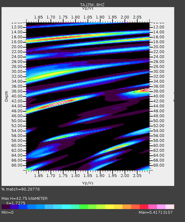
| Estimated Moho Depth: |
42.75 km |
| Estimated Crust Vp/Vs: |
1.73 |
| Assumed Crust Vp: |
6.566 km/s |
| Estimated Crust Vs: |
3.801 km/s |
| Estimated Crust Poisson's Ratio: |
0.25 |
|
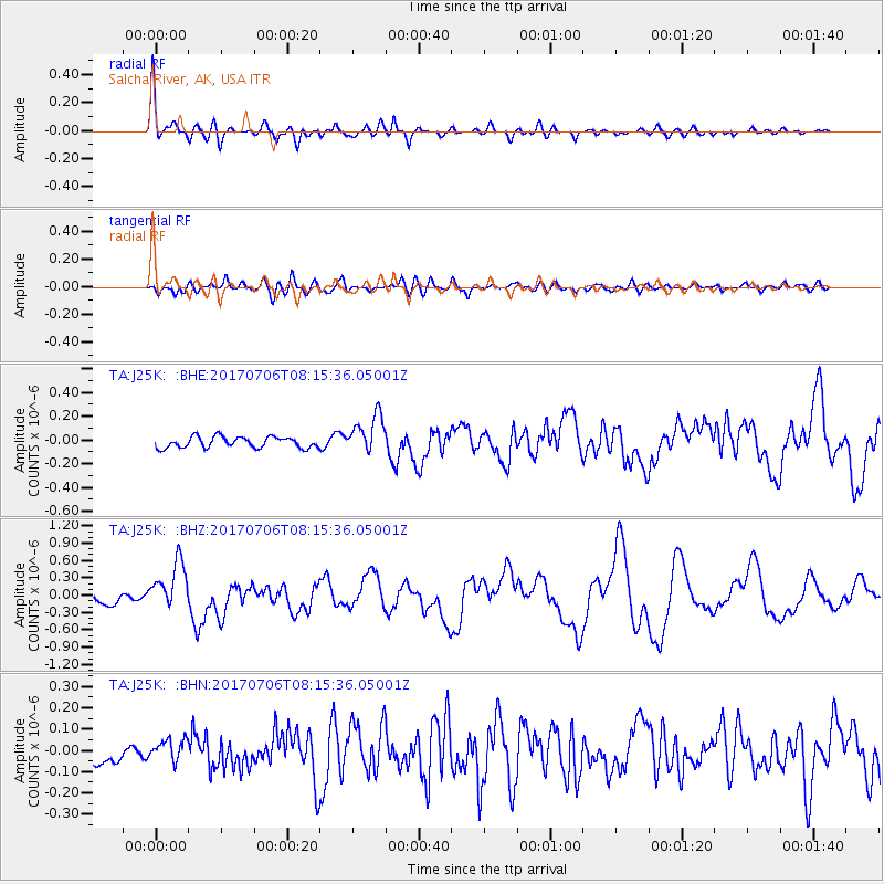
| Radial Match: |
90.28778 % |
| Radial Bump: |
400 |
| Transverse Match: |
61.23982 % |
| Transverse Bump: |
400 |
| SOD ConfigId: |
13570011 |
| Insert Time: |
2019-04-28 08:21:44.181 +0000 |
| GWidth: |
2.5 |
| Max Bumps: |
400 |
| Tol: |
0.001 |
|
Signal To Noise
| Channel | StoN | STA | LTA |
| TA:J25K: :BHZ:20170706T08:15:36.05001Z | 6.306394 | 4.1364382E-7 | 6.559118E-8 |
| TA:J25K: :BHN:20170706T08:15:36.05001Z | 1.007921 | 5.1095725E-8 | 5.0694176E-8 |
| TA:J25K: :BHE:20170706T08:15:36.05001Z | 3.515827 | 1.6373082E-7 | 4.6569646E-8 |
| Arrivals |
| Ps | 4.9 SECOND |
| PpPs | 17 SECOND |
| PsPs/PpSs | 22 SECOND |


