You are here: Home > Network List > TA - USArray Transportable Network (new EarthScope stations) Stations List
> Station R17K Ugashik Creek, AK, USA > Earthquake Result Viewer
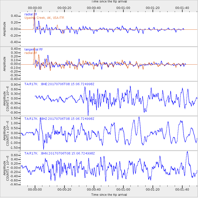
R17K Ugashik Creek, AK, USA - Earthquake Result Viewer
*The percent match for this event was below the threshold and hence no stack was calculated.
| Earthquake location: |
Leyte, Philippines |
| Earthquake latitude/longitude: |
11.1/124.6 |
| Earthquake time(UTC): |
2017/07/06 (187) 08:03:57 GMT |
| Earthquake Depth: |
6.5 km |
| Earthquake Magnitude: |
6.5 mww |
| Earthquake Catalog/Contributor: |
NEIC PDE/us |
|
| Network: |
TA USArray Transportable Network (new EarthScope stations) |
| Station: |
R17K Ugashik Creek, AK, USA |
| Lat/Lon: |
57.64 N/156.39 W |
| Elevation: |
273 m |
|
| Distance: |
74.8 deg |
| Az: |
33.165 deg |
| Baz: |
266.722 deg |
| Ray Param: |
$rayparam |
*The percent match for this event was below the threshold and hence was not used in the summary stack. |
|
| Radial Match: |
71.41876 % |
| Radial Bump: |
400 |
| Transverse Match: |
73.226265 % |
| Transverse Bump: |
400 |
| SOD ConfigId: |
13570011 |
| Insert Time: |
2019-04-28 08:22:41.012 +0000 |
| GWidth: |
2.5 |
| Max Bumps: |
400 |
| Tol: |
0.001 |
|
Signal To Noise
| Channel | StoN | STA | LTA |
| TA:R17K: :BHZ:20170706T08:15:06.724998Z | 6.565125 | 6.469376E-7 | 9.8541555E-8 |
| TA:R17K: :BHN:20170706T08:15:06.724998Z | 0.7322816 | 7.8790094E-8 | 1.0759535E-7 |
| TA:R17K: :BHE:20170706T08:15:06.724998Z | 2.3554957 | 2.7398514E-7 | 1.163174E-7 |
| Arrivals |
| Ps | |
| PpPs | |
| PsPs/PpSs | |


