You are here: Home > Network List > TA - USArray Transportable Network (new EarthScope stations) Stations List
> Station S31K Pelican, AK, USA > Earthquake Result Viewer
S31K Pelican, AK, USA - Earthquake Result Viewer
| Earthquake location: |
Leyte, Philippines |
| Earthquake latitude/longitude: |
11.1/124.6 |
| Earthquake time(UTC): |
2017/07/06 (187) 08:03:57 GMT |
| Earthquake Depth: |
6.5 km |
| Earthquake Magnitude: |
6.5 mww |
| Earthquake Catalog/Contributor: |
NEIC PDE/us |
|
| Network: |
TA USArray Transportable Network (new EarthScope stations) |
| Station: |
S31K Pelican, AK, USA |
| Lat/Lon: |
57.96 N/136.23 W |
| Elevation: |
34 m |
|
| Distance: |
85.5 deg |
| Az: |
31.866 deg |
| Baz: |
283.571 deg |
| Ray Param: |
0.044747658 |
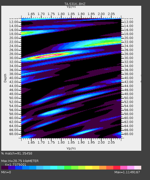
| Estimated Moho Depth: |
28.75 km |
| Estimated Crust Vp/Vs: |
1.74 |
| Assumed Crust Vp: |
6.134 km/s |
| Estimated Crust Vs: |
3.53 km/s |
| Estimated Crust Poisson's Ratio: |
0.25 |
|
| Radial Match: |
91.35458 % |
| Radial Bump: |
400 |
| Transverse Match: |
74.50132 % |
| Transverse Bump: |
400 |
| SOD ConfigId: |
13570011 |
| Insert Time: |
2019-04-28 08:22:43.221 +0000 |
| GWidth: |
2.5 |
| Max Bumps: |
400 |
| Tol: |
0.001 |
|

Signal To Noise
| Channel | StoN | STA | LTA |
| TA:S31K: :BHZ:20170706T08:16:04.125022Z | 4.4554505 | 3.374203E-7 | 7.5732025E-8 |
| TA:S31K: :BHN:20170706T08:16:04.125022Z | 0.9212425 | 6.906169E-8 | 7.496582E-8 |
| TA:S31K: :BHE:20170706T08:16:04.125022Z | 2.987437 | 2.1103274E-7 | 7.064006E-8 |
| Arrivals |
| Ps | 3.5 SECOND |
| PpPs | 13 SECOND |
| PsPs/PpSs | 16 SECOND |


