You are here: Home > Network List > TA - USArray Transportable Network (new EarthScope stations) Stations List
> Station TCOL CIGO, UAF Yankovich Road, Fairbanks, AK, USA > Earthquake Result Viewer
TCOL CIGO, UAF Yankovich Road, Fairbanks, AK, USA - Earthquake Result Viewer
| Earthquake location: |
Leyte, Philippines |
| Earthquake latitude/longitude: |
11.1/124.6 |
| Earthquake time(UTC): |
2017/07/06 (187) 08:03:57 GMT |
| Earthquake Depth: |
6.5 km |
| Earthquake Magnitude: |
6.5 mww |
| Earthquake Catalog/Contributor: |
NEIC PDE/us |
|
| Network: |
TA USArray Transportable Network (new EarthScope stations) |
| Station: |
TCOL CIGO, UAF Yankovich Road, Fairbanks, AK, USA |
| Lat/Lon: |
64.87 N/147.86 W |
| Elevation: |
178 m |
|
| Distance: |
79.0 deg |
| Az: |
25.759 deg |
| Baz: |
272.519 deg |
| Ray Param: |
0.049291756 |
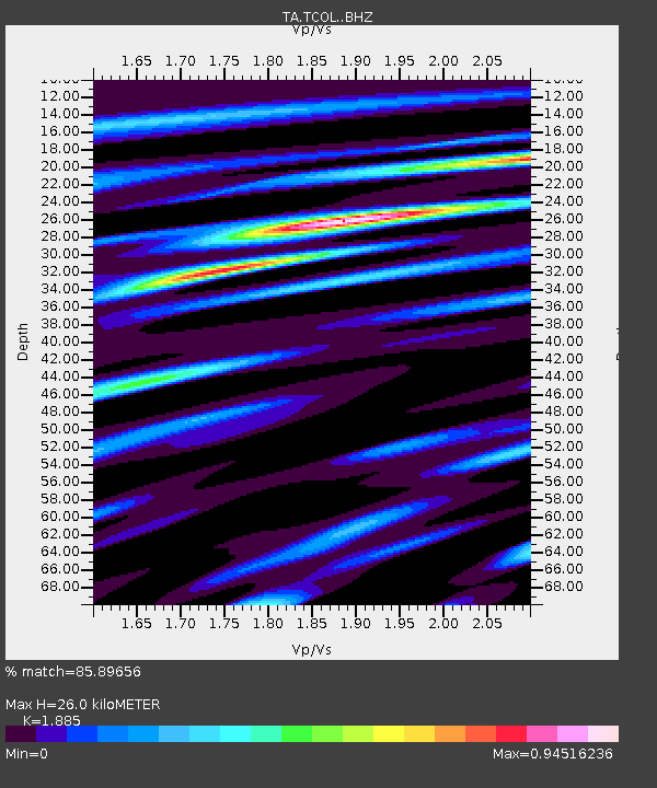
| Estimated Moho Depth: |
26.0 km |
| Estimated Crust Vp/Vs: |
1.88 |
| Assumed Crust Vp: |
6.566 km/s |
| Estimated Crust Vs: |
3.483 km/s |
| Estimated Crust Poisson's Ratio: |
0.30 |
|
| Radial Match: |
85.89656 % |
| Radial Bump: |
400 |
| Transverse Match: |
64.44607 % |
| Transverse Bump: |
400 |
| SOD ConfigId: |
13570011 |
| Insert Time: |
2019-04-28 08:22:46.139 +0000 |
| GWidth: |
2.5 |
| Max Bumps: |
400 |
| Tol: |
0.001 |
|

Signal To Noise
| Channel | StoN | STA | LTA |
| TA:TCOL: :BHZ:20170706T08:15:30.17501Z | 9.862155 | 5.8267955E-7 | 5.9082375E-8 |
| TA:TCOL: :BHN:20170706T08:15:30.17501Z | 1.3909311 | 1.2188858E-7 | 8.763092E-8 |
| TA:TCOL: :BHE:20170706T08:15:30.17501Z | 3.1122463 | 1.9966201E-7 | 6.415367E-8 |
| Arrivals |
| Ps | 3.6 SECOND |
| PpPs | 11 SECOND |
| PsPs/PpSs | 15 SECOND |


