You are here: Home > Network List > TA - USArray Transportable Network (new EarthScope stations) Stations List
> Station T30A Plains, KS, USA > Earthquake Result Viewer
T30A Plains, KS, USA - Earthquake Result Viewer
| Earthquake location: |
Samoa Islands Region |
| Earthquake latitude/longitude: |
-15.5/-172.1 |
| Earthquake time(UTC): |
2009/09/29 (272) 17:48:10 GMT |
| Earthquake Depth: |
18 km |
| Earthquake Magnitude: |
7.1 MB, 8.1 MS, 8.1 MW, 8.0 MW |
| Earthquake Catalog/Contributor: |
WHDF/NEIC |
|
| Network: |
TA USArray Transportable Network (new EarthScope stations) |
| Station: |
T30A Plains, KS, USA |
| Lat/Lon: |
37.05 N/100.53 W |
| Elevation: |
778 m |
|
| Distance: |
85.1 deg |
| Az: |
49.616 deg |
| Baz: |
246.632 deg |
| Ray Param: |
0.044961803 |
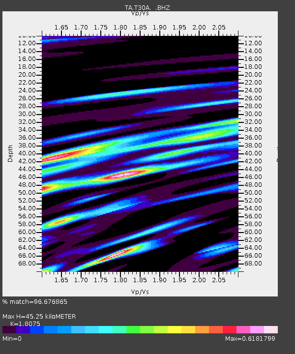
| Estimated Moho Depth: |
45.25 km |
| Estimated Crust Vp/Vs: |
1.81 |
| Assumed Crust Vp: |
6.483 km/s |
| Estimated Crust Vs: |
3.587 km/s |
| Estimated Crust Poisson's Ratio: |
0.28 |
|
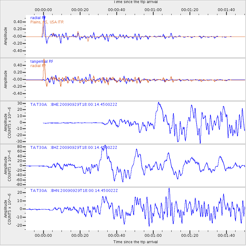
| Radial Match: |
96.676865 % |
| Radial Bump: |
400 |
| Transverse Match: |
81.650475 % |
| Transverse Bump: |
400 |
| SOD ConfigId: |
2622 |
| Insert Time: |
2010-03-06 01:39:34.396 +0000 |
| GWidth: |
2.5 |
| Max Bumps: |
400 |
| Tol: |
0.001 |
|
Signal To Noise
| Channel | StoN | STA | LTA |
| TA:T30A: :BHZ:20090929T18:00:14.450022Z | 12.859558 | 2.9431535E-6 | 2.2886894E-7 |
| TA:T30A: :BHN:20090929T18:00:14.450022Z | 2.0224297 | 5.1396233E-7 | 2.5413112E-7 |
| TA:T30A: :BHE:20090929T18:00:14.450022Z | 5.007317 | 1.1269964E-6 | 2.2506991E-7 |
| Arrivals |
| Ps | 5.8 SECOND |
| PpPs | 19 SECOND |
| PsPs/PpSs | 25 SECOND |


