You are here: Home > Network List > JP - Japan Meteorological Agency Seismic Network Stations List
> Station JMM Miyagi Marumori > Earthquake Result Viewer
JMM Miyagi Marumori - Earthquake Result Viewer
| Earthquake location: |
Eastern New Guinea Reg., P.N.G. |
| Earthquake latitude/longitude: |
-6.7/147.8 |
| Earthquake time(UTC): |
2017/07/07 (188) 03:42:52 GMT |
| Earthquake Depth: |
41 km |
| Earthquake Magnitude: |
5.7 Mww |
| Earthquake Catalog/Contributor: |
NEIC PDE/us |
|
| Network: |
JP Japan Meteorological Agency Seismic Network |
| Station: |
JMM Miyagi Marumori |
| Lat/Lon: |
37.87 N/140.79 E |
| Elevation: |
100 m |
|
| Distance: |
44.9 deg |
| Az: |
352.131 deg |
| Baz: |
170.107 deg |
| Ray Param: |
0.07155606 |
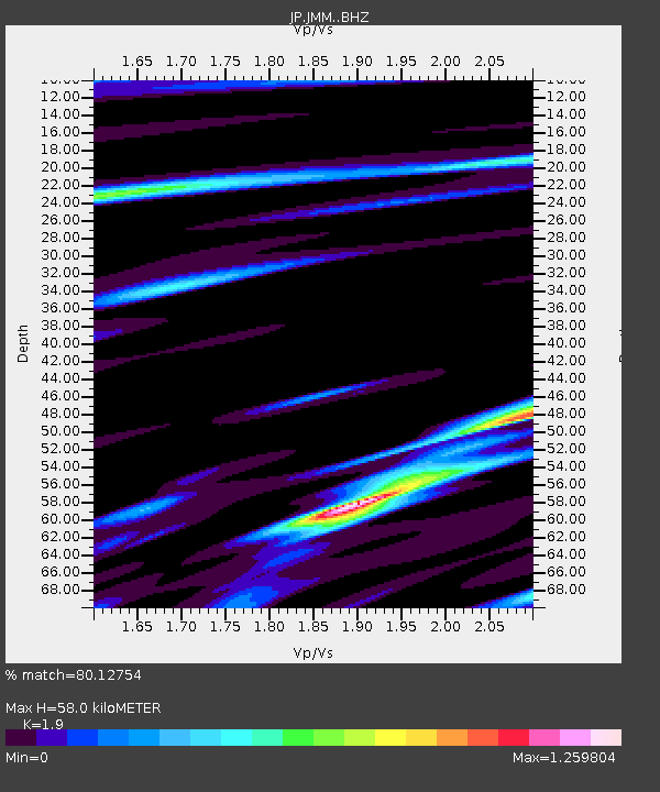
| Estimated Moho Depth: |
58.0 km |
| Estimated Crust Vp/Vs: |
1.90 |
| Assumed Crust Vp: |
6.24 km/s |
| Estimated Crust Vs: |
3.284 km/s |
| Estimated Crust Poisson's Ratio: |
0.31 |
|
| Radial Match: |
80.12754 % |
| Radial Bump: |
400 |
| Transverse Match: |
76.316315 % |
| Transverse Bump: |
400 |
| SOD ConfigId: |
13570011 |
| Insert Time: |
2019-04-28 08:26:14.359 +0000 |
| GWidth: |
2.5 |
| Max Bumps: |
400 |
| Tol: |
0.001 |
|

Signal To Noise
| Channel | StoN | STA | LTA |
| JP:JMM: :BHZ:20170707T03:50:31.799998Z | 3.235315 | 3.0652967E-7 | 9.474492E-8 |
| JP:JMM: :BHN:20170707T03:50:31.799998Z | 3.1751337 | 2.1691496E-7 | 6.8316794E-8 |
| JP:JMM: :BHE:20170707T03:50:31.799998Z | 1.4634215 | 9.622172E-8 | 6.57512E-8 |
| Arrivals |
| Ps | 8.8 SECOND |
| PpPs | 25 SECOND |
| PsPs/PpSs | 34 SECOND |


