You are here: Home > Network List > TA - USArray Transportable Network (new EarthScope stations) Stations List
> Station I23K Minto, Yukon-Koyukuk, AK, USA > Earthquake Result Viewer
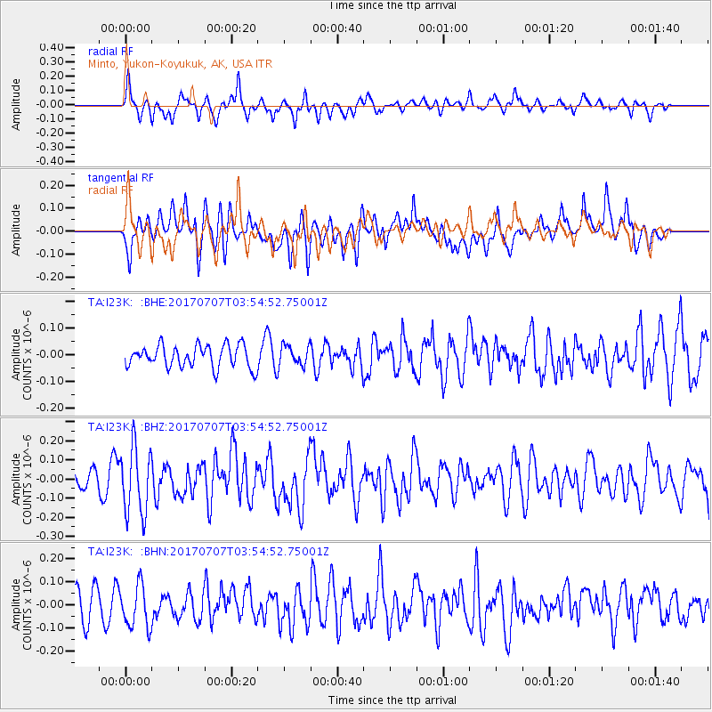
I23K Minto, Yukon-Koyukuk, AK, USA - Earthquake Result Viewer
*The percent match for this event was below the threshold and hence no stack was calculated.
| Earthquake location: |
Eastern New Guinea Reg., P.N.G. |
| Earthquake latitude/longitude: |
-6.7/147.8 |
| Earthquake time(UTC): |
2017/07/07 (188) 03:42:52 GMT |
| Earthquake Depth: |
41 km |
| Earthquake Magnitude: |
5.7 Mww |
| Earthquake Catalog/Contributor: |
NEIC PDE/us |
|
| Network: |
TA USArray Transportable Network (new EarthScope stations) |
| Station: |
I23K Minto, Yukon-Koyukuk, AK, USA |
| Lat/Lon: |
65.15 N/149.36 W |
| Elevation: |
149 m |
|
| Distance: |
85.1 deg |
| Az: |
22.173 deg |
| Baz: |
242.491 deg |
| Ray Param: |
$rayparam |
*The percent match for this event was below the threshold and hence was not used in the summary stack. |
|
| Radial Match: |
66.100464 % |
| Radial Bump: |
339 |
| Transverse Match: |
66.58862 % |
| Transverse Bump: |
400 |
| SOD ConfigId: |
13570011 |
| Insert Time: |
2019-04-28 08:27:19.933 +0000 |
| GWidth: |
2.5 |
| Max Bumps: |
400 |
| Tol: |
0.001 |
|
Signal To Noise
| Channel | StoN | STA | LTA |
| TA:I23K: :BHZ:20170707T03:54:52.75001Z | 4.5170283 | 1.7659474E-7 | 3.9095337E-8 |
| TA:I23K: :BHN:20170707T03:54:52.75001Z | 1.7472508 | 9.358524E-8 | 5.3561426E-8 |
| TA:I23K: :BHE:20170707T03:54:52.75001Z | 0.90148896 | 3.7283233E-8 | 4.1357392E-8 |
| Arrivals |
| Ps | |
| PpPs | |
| PsPs/PpSs | |


