You are here: Home > Network List > TA - USArray Transportable Network (new EarthScope stations) Stations List
> Station R17K Ugashik Creek, AK, USA > Earthquake Result Viewer
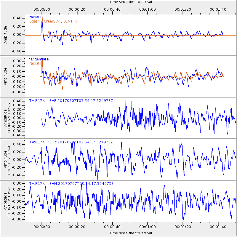
R17K Ugashik Creek, AK, USA - Earthquake Result Viewer
*The percent match for this event was below the threshold and hence no stack was calculated.
| Earthquake location: |
Eastern New Guinea Reg., P.N.G. |
| Earthquake latitude/longitude: |
-6.7/147.8 |
| Earthquake time(UTC): |
2017/07/07 (188) 03:42:52 GMT |
| Earthquake Depth: |
41 km |
| Earthquake Magnitude: |
5.7 Mww |
| Earthquake Catalog/Contributor: |
NEIC PDE/us |
|
| Network: |
TA USArray Transportable Network (new EarthScope stations) |
| Station: |
R17K Ugashik Creek, AK, USA |
| Lat/Lon: |
57.64 N/156.39 W |
| Elevation: |
273 m |
|
| Distance: |
78.4 deg |
| Az: |
27.015 deg |
| Baz: |
237.015 deg |
| Ray Param: |
$rayparam |
*The percent match for this event was below the threshold and hence was not used in the summary stack. |
|
| Radial Match: |
61.078648 % |
| Radial Bump: |
400 |
| Transverse Match: |
52.394215 % |
| Transverse Bump: |
400 |
| SOD ConfigId: |
13570011 |
| Insert Time: |
2019-04-28 08:27:52.816 +0000 |
| GWidth: |
2.5 |
| Max Bumps: |
400 |
| Tol: |
0.001 |
|
Signal To Noise
| Channel | StoN | STA | LTA |
| TA:R17K: :BHZ:20170707T03:54:17.524973Z | 2.3878005 | 2.3348348E-7 | 9.7781815E-8 |
| TA:R17K: :BHN:20170707T03:54:17.524973Z | 1.2953833 | 1.229194E-7 | 9.489037E-8 |
| TA:R17K: :BHE:20170707T03:54:17.524973Z | 0.69086146 | 6.749444E-8 | 9.769605E-8 |
| Arrivals |
| Ps | |
| PpPs | |
| PsPs/PpSs | |


