You are here: Home > Network List > UW - Pacific Northwest Regional Seismic Network Stations List
> Station FISH Seaside, OR, USA > Earthquake Result Viewer
FISH Seaside, OR, USA - Earthquake Result Viewer
*The percent match for this event was below the threshold and hence no stack was calculated.
| Earthquake location: |
Eastern New Guinea Reg., P.N.G. |
| Earthquake latitude/longitude: |
-6.7/147.8 |
| Earthquake time(UTC): |
2017/07/07 (188) 03:42:52 GMT |
| Earthquake Depth: |
41 km |
| Earthquake Magnitude: |
5.7 Mww |
| Earthquake Catalog/Contributor: |
NEIC PDE/us |
|
| Network: |
UW Pacific Northwest Regional Seismic Network |
| Station: |
FISH Seaside, OR, USA |
| Lat/Lon: |
45.93 N/123.56 W |
| Elevation: |
325 m |
|
| Distance: |
93.8 deg |
| Az: |
44.372 deg |
| Baz: |
264.346 deg |
| Ray Param: |
$rayparam |
*The percent match for this event was below the threshold and hence was not used in the summary stack. |
|
| Radial Match: |
22.445219 % |
| Radial Bump: |
400 |
| Transverse Match: |
39.156067 % |
| Transverse Bump: |
400 |
| SOD ConfigId: |
13570011 |
| Insert Time: |
2019-04-28 08:28:11.048 +0000 |
| GWidth: |
2.5 |
| Max Bumps: |
400 |
| Tol: |
0.001 |
|
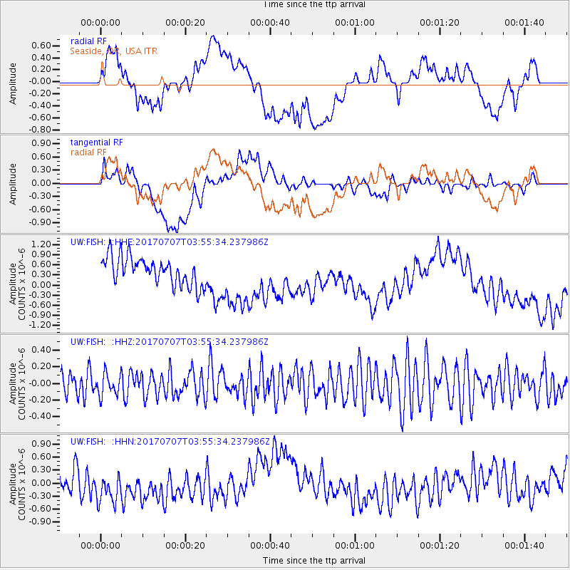
Signal To Noise
| Channel | StoN | STA | LTA |
| UW:FISH: :HHZ:20170707T03:55:34.237986Z | 0.58675617 | 1.3464137E-7 | 2.294673E-7 |
| UW:FISH: :HHN:20170707T03:55:34.237986Z | 1.4585729 | 5.0420107E-7 | 3.4568112E-7 |
| UW:FISH: :HHE:20170707T03:55:34.237986Z | 2.2512994 | 9.146091E-7 | 4.0625832E-7 |
| Arrivals |
| Ps | |
| PpPs | |
| PsPs/PpSs | |


