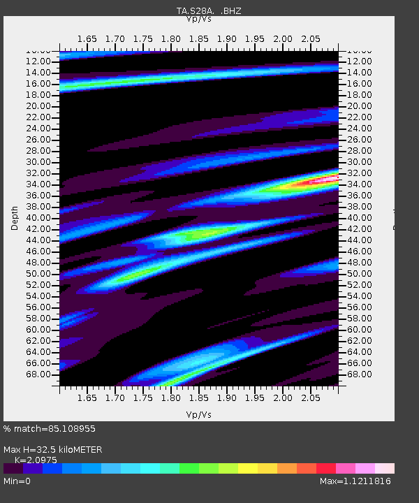
S28A Manter, KS, USA - Earthquake Result Viewer

Earthquake location: Fox Islands, Aleutian Islands
Earthquake latitude/longitude: 52.6/-167.1
Earthquake time(UTC): 2009/10/13 (286) 20:21:53 GMT
Earthquake Depth: 14 km
Earthquake Magnitude: 5.9 MB, 6.4 MS, 6.4 MW, 6.4 MW
Earthquake Catalog/Contributor: WHDF/NEIC
Network: TA USArray Transportable Network (new EarthScope stations)
Station: S28A Manter, KS, USA
Lat/Lon: 37.59 N/101.90 W
Elevation: 1064 m
Distance: 46.8 deg
Az: 81.591 deg
Baz: 310.578 deg
Ray Param: 0.0703986
Estimated Moho Depth: 32.5 km
Estimated Crust Vp/Vs: 2.10
Assumed Crust Vp: 6.483 km/s
Estimated Crust Vs: 3.091 km/s
Estimated Crust Poisson's Ratio: 0.35
Radial Match: 85.108955 %
Radial Bump: 340
Transverse Match: 66.92215 %
Transverse Bump: 400
SOD ConfigId: 2622
Insert Time: 2010-03-06 01:40:53.448 +0000
GWidth: 2.5
Max Bumps: 400
Tol: 0.001

Signal To Noise

ChannelStoNSTALTA
TA:S28A: :BHZ:20091013T20:29:51.374011Z2.7355074.4411217E-71.6235094E-7
TA:S28A: :BHN:20091013T20:29:51.374011Z0.81461211.5394434E-71.8897872E-7
TA:S28A: :BHE:20091013T20:29:51.374011Z1.17019864.1890615E-73.579787E-7
Arrivals
Ps5.8 SECOND
PpPs15 SECOND
PsPs/PpSs21 SECOND