You are here: Home > Network List > TA - USArray Transportable Network (new EarthScope stations) Stations List
> Station S28A Manter, KS, USA > Earthquake Result Viewer
S28A Manter, KS, USA - Earthquake Result Viewer
| Earthquake location: |
Samoa Islands Region |
| Earthquake latitude/longitude: |
-15.4/-172.3 |
| Earthquake time(UTC): |
2009/10/19 (292) 22:49:38 GMT |
| Earthquake Depth: |
18 km |
| Earthquake Magnitude: |
6.2 MB, 5.7 MS, 6.0 MW, 5.9 MW |
| Earthquake Catalog/Contributor: |
WHDF/NEIC |
|
| Network: |
TA USArray Transportable Network (new EarthScope stations) |
| Station: |
S28A Manter, KS, USA |
| Lat/Lon: |
37.59 N/101.90 W |
| Elevation: |
1064 m |
|
| Distance: |
84.4 deg |
| Az: |
48.744 deg |
| Baz: |
245.923 deg |
| Ray Param: |
0.045497254 |
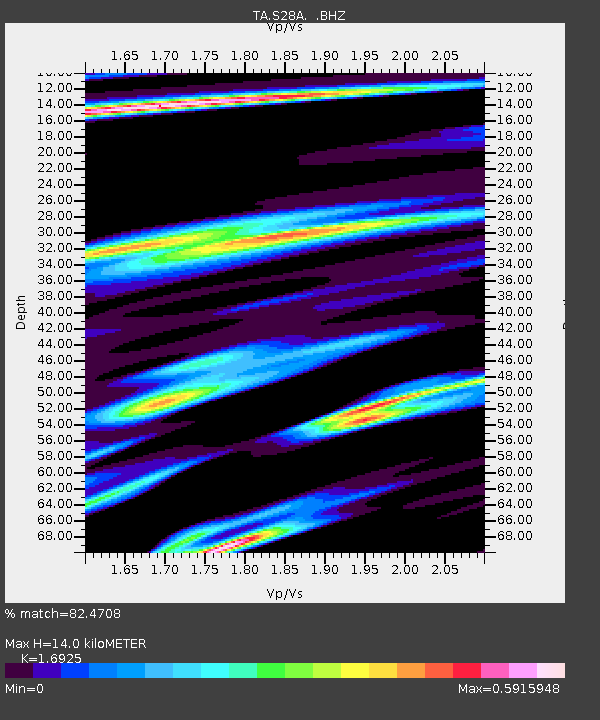
| Estimated Moho Depth: |
14.0 km |
| Estimated Crust Vp/Vs: |
1.69 |
| Assumed Crust Vp: |
6.483 km/s |
| Estimated Crust Vs: |
3.83 km/s |
| Estimated Crust Poisson's Ratio: |
0.23 |
|
| Radial Match: |
82.4708 % |
| Radial Bump: |
335 |
| Transverse Match: |
66.20487 % |
| Transverse Bump: |
327 |
| SOD ConfigId: |
2622 |
| Insert Time: |
2010-03-06 01:40:55.764 +0000 |
| GWidth: |
2.5 |
| Max Bumps: |
400 |
| Tol: |
0.001 |
|
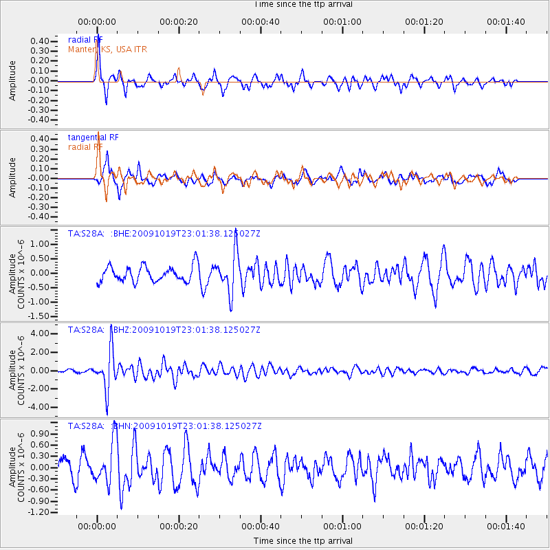
Signal To Noise
| Channel | StoN | STA | LTA |
| TA:S28A: :BHZ:20091019T23:01:38.125027Z | 8.067122 | 2.1766614E-6 | 2.6981883E-7 |
| TA:S28A: :BHN:20091019T23:01:38.125027Z | 2.5516794 | 5.892301E-7 | 2.3091854E-7 |
| TA:S28A: :BHE:20091019T23:01:38.125027Z | 2.6439726 | 7.0424966E-7 | 2.6636042E-7 |
| Arrivals |
| Ps | 1.5 SECOND |
| PpPs | 5.7 SECOND |
| PsPs/PpSs | 7.2 SECOND |


