You are here: Home > Network List > TA - USArray Transportable Network (new EarthScope stations) Stations List
> Station S28A Manter, KS, USA > Earthquake Result Viewer
S28A Manter, KS, USA - Earthquake Result Viewer
| Earthquake location: |
Azores Islands Region |
| Earthquake latitude/longitude: |
36.2/-33.9 |
| Earthquake time(UTC): |
2009/11/04 (308) 18:41:44 GMT |
| Earthquake Depth: |
10 km |
| Earthquake Magnitude: |
5.7 MB, 5.6 MS, 5.9 MW, 5.8 MW |
| Earthquake Catalog/Contributor: |
WHDF/NEIC |
|
| Network: |
TA USArray Transportable Network (new EarthScope stations) |
| Station: |
S28A Manter, KS, USA |
| Lat/Lon: |
37.59 N/101.90 W |
| Elevation: |
1064 m |
|
| Distance: |
53.3 deg |
| Az: |
293.283 deg |
| Baz: |
69.365 deg |
| Ray Param: |
0.06618054 |
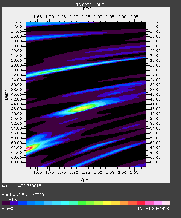
| Estimated Moho Depth: |
62.5 km |
| Estimated Crust Vp/Vs: |
1.60 |
| Assumed Crust Vp: |
6.483 km/s |
| Estimated Crust Vs: |
4.052 km/s |
| Estimated Crust Poisson's Ratio: |
0.18 |
|
| Radial Match: |
82.753815 % |
| Radial Bump: |
307 |
| Transverse Match: |
57.94914 % |
| Transverse Bump: |
400 |
| SOD ConfigId: |
2622 |
| Insert Time: |
2010-03-06 01:40:57.414 +0000 |
| GWidth: |
2.5 |
| Max Bumps: |
400 |
| Tol: |
0.001 |
|

Signal To Noise
| Channel | StoN | STA | LTA |
| TA:S28A: :BHZ:20091104T18:50:32.500015Z | 12.316822 | 1.1653717E-6 | 9.461626E-8 |
| TA:S28A: :BHN:20091104T18:50:32.500015Z | 1.8689116 | 3.309569E-7 | 1.7708537E-7 |
| TA:S28A: :BHE:20091104T18:50:32.500015Z | 3.7847831 | 6.9794334E-7 | 1.8440775E-7 |
| Arrivals |
| Ps | 6.2 SECOND |
| PpPs | 24 SECOND |
| PsPs/PpSs | 30 SECOND |


