S28A Manter, KS, USA - Earthquake Result Viewer
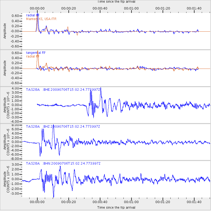
Earthquake location: Rat Islands, Aleutian Islands
Earthquake latitude/longitude: 50.4/177.0
Earthquake time(UTC): 2009/07/06 (187) 14:53:12 GMT
Earthquake Depth: 22 km
Earthquake Magnitude: 6.0 MB, 5.8 MS, 6.1 MW, 6.0 MW
Earthquake Catalog/Contributor: WHDF/NEIC
Network: TA USArray Transportable Network (new EarthScope stations)
Station: S28A Manter, KS, USA
Lat/Lon: 37.59 N/101.90 W
Elevation: 1064 m
Distance: 56.9 deg
Az: 69.459 deg
Baz: 311.075 deg
Ray Param: 0.06378276
Estimated Moho Depth: 45.75 km
Estimated Crust Vp/Vs: 1.78
Assumed Crust Vp: 6.483 km/s
Estimated Crust Vs: 3.637 km/s
Estimated Crust Poisson's Ratio: 0.27
Radial Match: 95.5027 %
Radial Bump: 358
Transverse Match: 81.0411 %
Transverse Bump: 400
SOD ConfigId: 2648
Insert Time: 2010-03-06 01:41:07.512 +0000
GWidth: 2.5
Max Bumps: 400
Tol: 0.001

Signal To Noise

ChannelStoNSTALTA
TA:S28A: :BHZ:20090706T15:02:24.773997Z17.9879323.0924489E-61.7191797E-7
TA:S28A: :BHN:20090706T15:02:24.773997Z5.1579321.1252855E-62.1816604E-7
TA:S28A: :BHE:20090706T15:02:24.773997Z11.3868321.4554117E-61.2781534E-7
Arrivals
Ps5.8 SECOND
PpPs19 SECOND
PsPs/PpSs24 SECOND