You are here: Home > Network List > TA - USArray Transportable Network (new EarthScope stations) Stations List
> Station S28A Manter, KS, USA > Earthquake Result Viewer
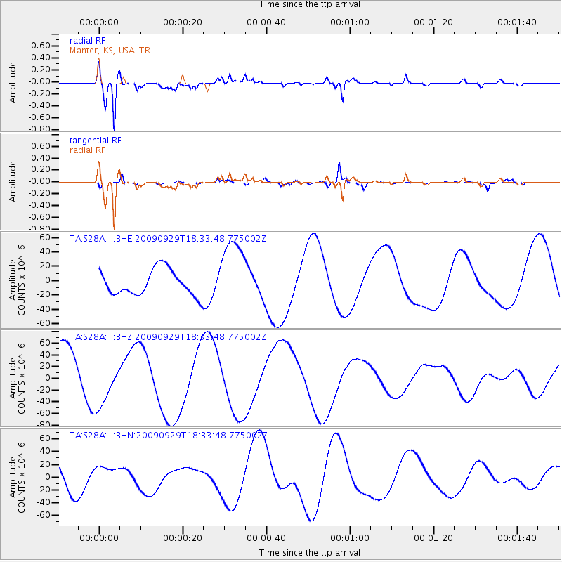
S28A Manter, KS, USA - Earthquake Result Viewer
*The percent match for this event was below the threshold and hence no stack was calculated.
| Earthquake location: |
Samoa Islands Region |
| Earthquake latitude/longitude: |
-16.2/-173.0 |
| Earthquake time(UTC): |
2009/09/29 (272) 18:21:42 GMT |
| Earthquake Depth: |
10 km |
| Earthquake Magnitude: |
5.8 MB |
| Earthquake Catalog/Contributor: |
WHDF/NEIC |
|
| Network: |
TA USArray Transportable Network (new EarthScope stations) |
| Station: |
S28A Manter, KS, USA |
| Lat/Lon: |
37.59 N/101.90 W |
| Elevation: |
1064 m |
|
| Distance: |
85.5 deg |
| Az: |
48.921 deg |
| Baz: |
245.741 deg |
| Ray Param: |
$rayparam |
*The percent match for this event was below the threshold and hence was not used in the summary stack. |
|
| Radial Match: |
92.76751 % |
| Radial Bump: |
324 |
| Transverse Match: |
55.896008 % |
| Transverse Bump: |
264 |
| SOD ConfigId: |
2622 |
| Insert Time: |
2010-03-06 01:41:30.583 +0000 |
| GWidth: |
2.5 |
| Max Bumps: |
400 |
| Tol: |
0.001 |
|
Signal To Noise
| Channel | StoN | STA | LTA |
| TA:S28A: :BHZ:20090929T18:33:48.775002Z | 0.8654359 | 3.8246337E-5 | 4.419315E-5 |
| TA:S28A: :BHN:20090929T18:33:48.775002Z | 0.61854285 | 1.5336433E-5 | 2.4794455E-5 |
| TA:S28A: :BHE:20090929T18:33:48.775002Z | 2.8072648 | 4.945886E-5 | 1.7618167E-5 |
| Arrivals |
| Ps | |
| PpPs | |
| PsPs/PpSs | |


