You are here: Home > Network List > TA - USArray Transportable Network (new EarthScope stations) Stations List
> Station S28A Manter, KS, USA > Earthquake Result Viewer
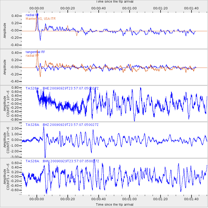
S28A Manter, KS, USA - Earthquake Result Viewer
*The percent match for this event was below the threshold and hence no stack was calculated.
| Earthquake location: |
Samoa Islands Region |
| Earthquake latitude/longitude: |
-15.8/-172.6 |
| Earthquake time(UTC): |
2009/09/29 (272) 23:45:03 GMT |
| Earthquake Depth: |
10 km |
| Earthquake Magnitude: |
6.0 MB, 5.8 MS |
| Earthquake Catalog/Contributor: |
WHDF/NEIC |
|
| Network: |
TA USArray Transportable Network (new EarthScope stations) |
| Station: |
S28A Manter, KS, USA |
| Lat/Lon: |
37.59 N/101.90 W |
| Elevation: |
1064 m |
|
| Distance: |
84.9 deg |
| Az: |
48.805 deg |
| Baz: |
245.752 deg |
| Ray Param: |
$rayparam |
*The percent match for this event was below the threshold and hence was not used in the summary stack. |
|
| Radial Match: |
77.42414 % |
| Radial Bump: |
375 |
| Transverse Match: |
63.52682 % |
| Transverse Bump: |
388 |
| SOD ConfigId: |
2622 |
| Insert Time: |
2010-03-06 01:41:32.261 +0000 |
| GWidth: |
2.5 |
| Max Bumps: |
400 |
| Tol: |
0.001 |
|
Signal To Noise
| Channel | StoN | STA | LTA |
| TA:S28A: :BHZ:20090929T23:57:07.050027Z | 4.509478 | 8.1340414E-7 | 1.8037655E-7 |
| TA:S28A: :BHN:20090929T23:57:07.050027Z | 0.9817032 | 2.029527E-7 | 2.0673531E-7 |
| TA:S28A: :BHE:20090929T23:57:07.050027Z | 1.4108919 | 3.475401E-7 | 2.4632652E-7 |
| Arrivals |
| Ps | |
| PpPs | |
| PsPs/PpSs | |


