You are here: Home > Network List > TA - USArray Transportable Network (new EarthScope stations) Stations List
> Station S28A Manter, KS, USA > Earthquake Result Viewer
S28A Manter, KS, USA - Earthquake Result Viewer
*The percent match for this event was below the threshold and hence no stack was calculated.
| Earthquake location: |
Rat Islands, Aleutian Islands |
| Earthquake latitude/longitude: |
52.2/178.1 |
| Earthquake time(UTC): |
2009/10/07 (280) 05:38:37 GMT |
| Earthquake Depth: |
138 km |
| Earthquake Magnitude: |
5.6 MB, 5.6 MW, 5.6 MW |
| Earthquake Catalog/Contributor: |
WHDF/NEIC |
|
| Network: |
TA USArray Transportable Network (new EarthScope stations) |
| Station: |
S28A Manter, KS, USA |
| Lat/Lon: |
37.59 N/101.90 W |
| Elevation: |
1064 m |
|
| Distance: |
55.7 deg |
| Az: |
71.217 deg |
| Baz: |
312.757 deg |
| Ray Param: |
$rayparam |
*The percent match for this event was below the threshold and hence was not used in the summary stack. |
|
| Radial Match: |
64.52443 % |
| Radial Bump: |
400 |
| Transverse Match: |
62.43978 % |
| Transverse Bump: |
400 |
| SOD ConfigId: |
2622 |
| Insert Time: |
2010-03-06 01:41:34.614 +0000 |
| GWidth: |
2.5 |
| Max Bumps: |
400 |
| Tol: |
0.001 |
|
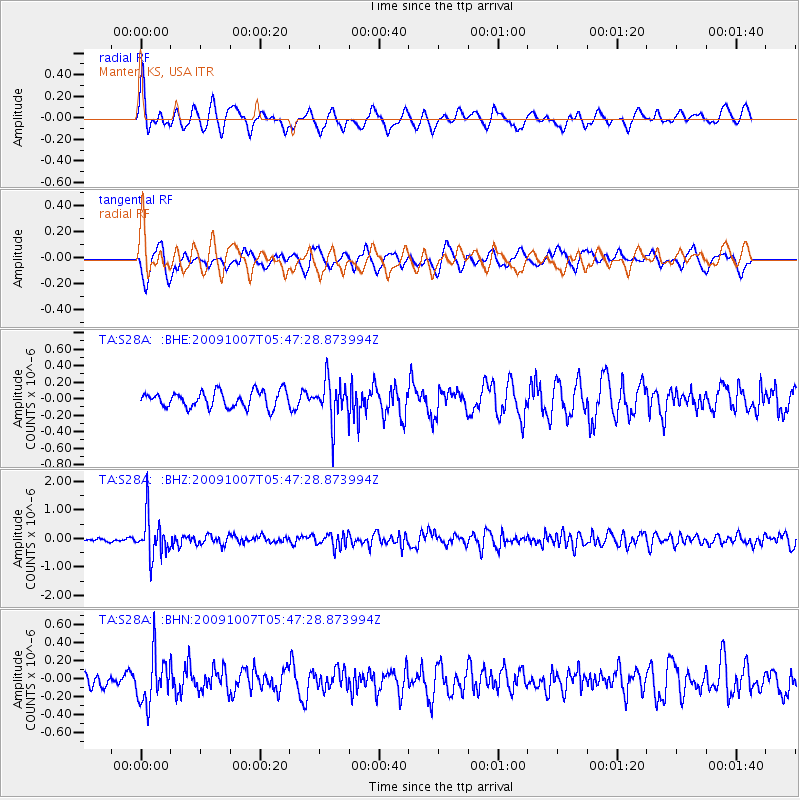
Signal To Noise
| Channel | StoN | STA | LTA |
| TA:S28A: :BHZ:20091007T05:47:28.873994Z | 8.019021 | 7.159916E-7 | 8.928665E-8 |
| TA:S28A: :BHN:20091007T05:47:28.873994Z | 2.1077576 | 2.659545E-7 | 1.2617889E-7 |
| TA:S28A: :BHE:20091007T05:47:28.873994Z | 2.5689745 | 2.4862493E-7 | 9.6779836E-8 |
| Arrivals |
| Ps | |
| PpPs | |
| PsPs/PpSs | |


