You are here: Home > Network List > TA - USArray Transportable Network (new EarthScope stations) Stations List
> Station S28A Manter, KS, USA > Earthquake Result Viewer
S28A Manter, KS, USA - Earthquake Result Viewer
*The percent match for this event was below the threshold and hence no stack was calculated.
| Earthquake location: |
Near East Coast Of Honshu, Japan |
| Earthquake latitude/longitude: |
35.5/140.9 |
| Earthquake time(UTC): |
2009/06/06 (157) 05:52:43 GMT |
| Earthquake Depth: |
34 km |
| Earthquake Magnitude: |
5.8 MB, 5.4 MS, 5.8 MW, 5.7 MW |
| Earthquake Catalog/Contributor: |
WHDF/NEIC |
|
| Network: |
TA USArray Transportable Network (new EarthScope stations) |
| Station: |
S28A Manter, KS, USA |
| Lat/Lon: |
37.59 N/101.90 W |
| Elevation: |
1064 m |
|
| Distance: |
86.9 deg |
| Az: |
45.045 deg |
| Baz: |
313.361 deg |
| Ray Param: |
$rayparam |
*The percent match for this event was below the threshold and hence was not used in the summary stack. |
|
| Radial Match: |
71.408165 % |
| Radial Bump: |
400 |
| Transverse Match: |
58.107384 % |
| Transverse Bump: |
400 |
| SOD ConfigId: |
2648 |
| Insert Time: |
2010-03-06 01:41:39.692 +0000 |
| GWidth: |
2.5 |
| Max Bumps: |
400 |
| Tol: |
0.001 |
|
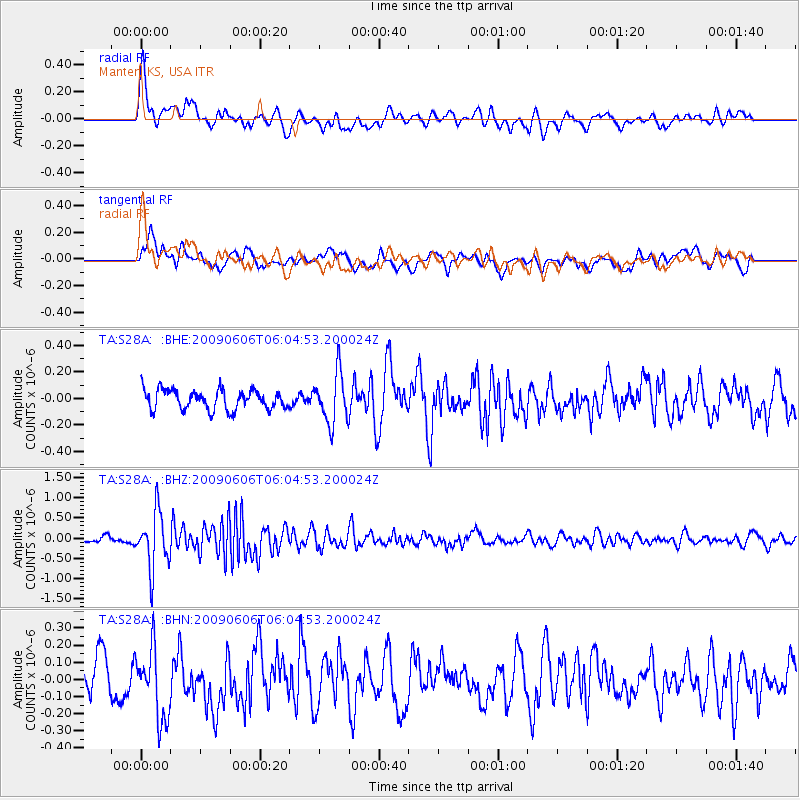
Signal To Noise
| Channel | StoN | STA | LTA |
| TA:S28A: :BHZ:20090606T06:04:53.200024Z | 10.8192215 | 6.8813347E-7 | 6.360287E-8 |
| TA:S28A: :BHN:20090606T06:04:53.200024Z | 1.9916048 | 2.0765968E-7 | 1.04267514E-7 |
| TA:S28A: :BHE:20090606T06:04:53.200024Z | 2.575093 | 1.8939376E-7 | 7.3548314E-8 |
| Arrivals |
| Ps | |
| PpPs | |
| PsPs/PpSs | |


