You are here: Home > Network List > TA - USArray Transportable Network (new EarthScope stations) Stations List
> Station 833A Chaparral WMA, Artesia Wells, TX, USA > Earthquake Result Viewer
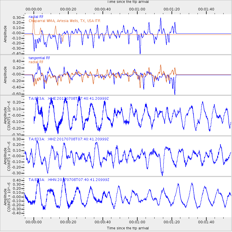
833A Chaparral WMA, Artesia Wells, TX, USA - Earthquake Result Viewer
*The percent match for this event was below the threshold and hence no stack was calculated.
| Earthquake location: |
Southeast Of Loyalty Islands |
| Earthquake latitude/longitude: |
-22.6/173.1 |
| Earthquake time(UTC): |
2017/07/08 (189) 07:27:35 GMT |
| Earthquake Depth: |
10 km |
| Earthquake Magnitude: |
5.6 Mww |
| Earthquake Catalog/Contributor: |
NEIC PDE/us |
|
| Network: |
TA USArray Transportable Network (new EarthScope stations) |
| Station: |
833A Chaparral WMA, Artesia Wells, TX, USA |
| Lat/Lon: |
28.32 N/99.39 W |
| Elevation: |
171 m |
|
| Distance: |
98.3 deg |
| Az: |
62.887 deg |
| Baz: |
248.937 deg |
| Ray Param: |
$rayparam |
*The percent match for this event was below the threshold and hence was not used in the summary stack. |
|
| Radial Match: |
67.27231 % |
| Radial Bump: |
400 |
| Transverse Match: |
75.79643 % |
| Transverse Bump: |
260 |
| SOD ConfigId: |
13570011 |
| Insert Time: |
2019-04-28 08:34:04.585 +0000 |
| GWidth: |
2.5 |
| Max Bumps: |
400 |
| Tol: |
0.001 |
|
Signal To Noise
| Channel | StoN | STA | LTA |
| TA:833A: :HHZ:20170708T07:40:41.20999Z | 1.8613956 | 1.464015E-7 | 7.865147E-8 |
| TA:833A: :HHN:20170708T07:40:41.20999Z | 2.452922 | 2.2205599E-7 | 9.0527124E-8 |
| TA:833A: :HHE:20170708T07:40:41.20999Z | 0.772212 | 1.1574878E-7 | 1.4989249E-7 |
| Arrivals |
| Ps | |
| PpPs | |
| PsPs/PpSs | |


