You are here: Home > Network List > TA - USArray Transportable Network (new EarthScope stations) Stations List
> Station M16K Timber Creek, AK, USA > Earthquake Result Viewer
M16K Timber Creek, AK, USA - Earthquake Result Viewer
| Earthquake location: |
Southeast Of Loyalty Islands |
| Earthquake latitude/longitude: |
-22.6/173.1 |
| Earthquake time(UTC): |
2017/07/08 (189) 07:27:35 GMT |
| Earthquake Depth: |
10 km |
| Earthquake Magnitude: |
5.6 Mww |
| Earthquake Catalog/Contributor: |
NEIC PDE/us |
|
| Network: |
TA USArray Transportable Network (new EarthScope stations) |
| Station: |
M16K Timber Creek, AK, USA |
| Lat/Lon: |
61.02 N/158.96 W |
| Elevation: |
394 m |
|
| Distance: |
86.3 deg |
| Az: |
13.212 deg |
| Baz: |
205.709 deg |
| Ray Param: |
0.044137888 |
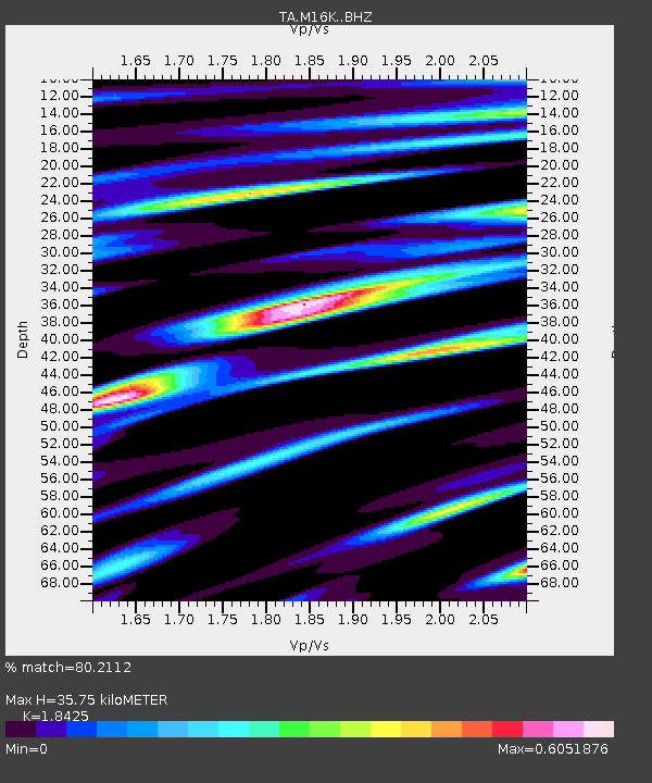
| Estimated Moho Depth: |
35.75 km |
| Estimated Crust Vp/Vs: |
1.84 |
| Assumed Crust Vp: |
6.276 km/s |
| Estimated Crust Vs: |
3.406 km/s |
| Estimated Crust Poisson's Ratio: |
0.29 |
|
| Radial Match: |
80.2112 % |
| Radial Bump: |
400 |
| Transverse Match: |
60.407604 % |
| Transverse Bump: |
400 |
| SOD ConfigId: |
13570011 |
| Insert Time: |
2019-04-28 08:34:58.797 +0000 |
| GWidth: |
2.5 |
| Max Bumps: |
400 |
| Tol: |
0.001 |
|
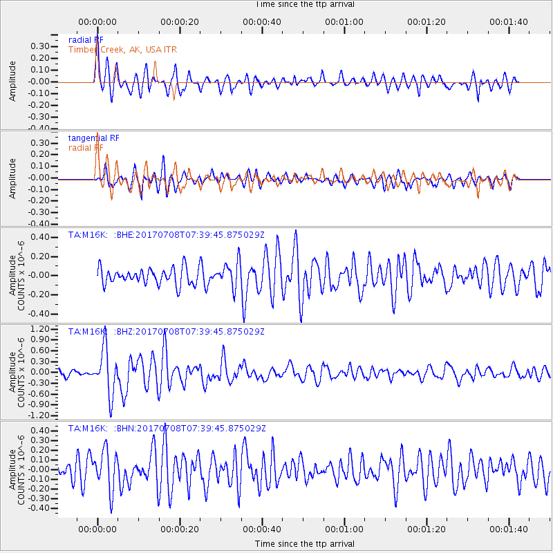
Signal To Noise
| Channel | StoN | STA | LTA |
| TA:M16K: :BHZ:20170708T07:39:45.875029Z | 6.392738 | 6.541455E-7 | 1.0232634E-7 |
| TA:M16K: :BHN:20170708T07:39:45.875029Z | 3.0044513 | 2.1026294E-7 | 6.998381E-8 |
| TA:M16K: :BHE:20170708T07:39:45.875029Z | 1.6222714 | 1.3466902E-7 | 8.301264E-8 |
| Arrivals |
| Ps | 4.9 SECOND |
| PpPs | 16 SECOND |
| PsPs/PpSs | 21 SECOND |


