You are here: Home > Network List > TA - USArray Transportable Network (new EarthScope stations) Stations List
> Station R17K Ugashik Creek, AK, USA > Earthquake Result Viewer
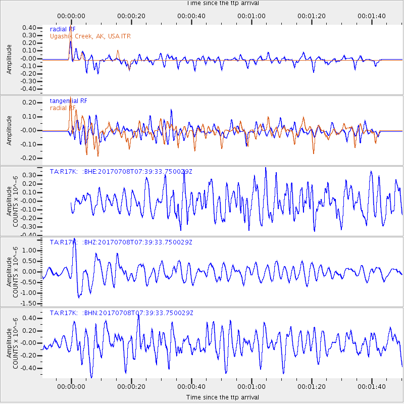
R17K Ugashik Creek, AK, USA - Earthquake Result Viewer
*The percent match for this event was below the threshold and hence no stack was calculated.
| Earthquake location: |
Southeast Of Loyalty Islands |
| Earthquake latitude/longitude: |
-22.6/173.1 |
| Earthquake time(UTC): |
2017/07/08 (189) 07:27:35 GMT |
| Earthquake Depth: |
10 km |
| Earthquake Magnitude: |
5.6 Mww |
| Earthquake Catalog/Contributor: |
NEIC PDE/us |
|
| Network: |
TA USArray Transportable Network (new EarthScope stations) |
| Station: |
R17K Ugashik Creek, AK, USA |
| Lat/Lon: |
57.64 N/156.39 W |
| Elevation: |
273 m |
|
| Distance: |
83.9 deg |
| Az: |
15.934 deg |
| Baz: |
208.151 deg |
| Ray Param: |
$rayparam |
*The percent match for this event was below the threshold and hence was not used in the summary stack. |
|
| Radial Match: |
74.64142 % |
| Radial Bump: |
400 |
| Transverse Match: |
66.958984 % |
| Transverse Bump: |
400 |
| SOD ConfigId: |
13570011 |
| Insert Time: |
2019-04-28 08:35:37.858 +0000 |
| GWidth: |
2.5 |
| Max Bumps: |
400 |
| Tol: |
0.001 |
|
Signal To Noise
| Channel | StoN | STA | LTA |
| TA:R17K: :BHZ:20170708T07:39:33.750029Z | 5.282973 | 8.2238535E-7 | 1.5566715E-7 |
| TA:R17K: :BHN:20170708T07:39:33.750029Z | 1.779053 | 1.8911882E-7 | 1.0630309E-7 |
| TA:R17K: :BHE:20170708T07:39:33.750029Z | 1.5650525 | 1.4017955E-7 | 8.9568594E-8 |
| Arrivals |
| Ps | |
| PpPs | |
| PsPs/PpSs | |


