You are here: Home > Network List > TA - USArray Transportable Network (new EarthScope stations) Stations List
> Station V35K Ketchikan, AK, USA > Earthquake Result Viewer
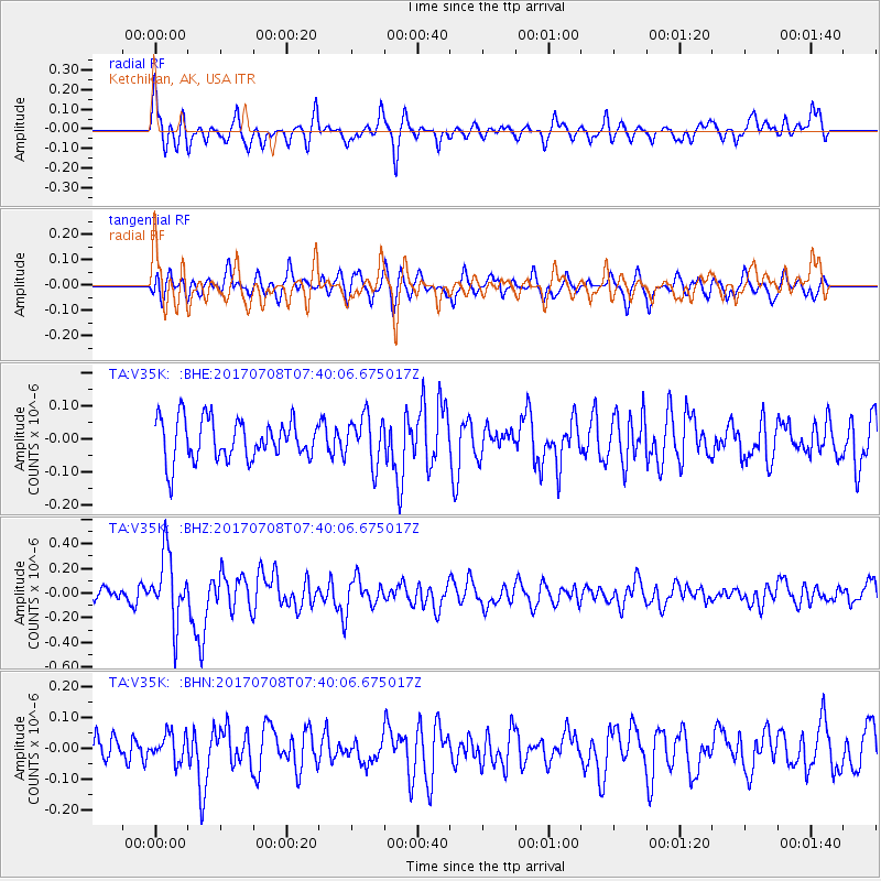
V35K Ketchikan, AK, USA - Earthquake Result Viewer
*The percent match for this event was below the threshold and hence no stack was calculated.
| Earthquake location: |
Southeast Of Loyalty Islands |
| Earthquake latitude/longitude: |
-22.6/173.1 |
| Earthquake time(UTC): |
2017/07/08 (189) 07:27:35 GMT |
| Earthquake Depth: |
10 km |
| Earthquake Magnitude: |
5.6 Mww |
| Earthquake Catalog/Contributor: |
NEIC PDE/us |
|
| Network: |
TA USArray Transportable Network (new EarthScope stations) |
| Station: |
V35K Ketchikan, AK, USA |
| Lat/Lon: |
55.33 N/131.62 W |
| Elevation: |
64 m |
|
| Distance: |
90.7 deg |
| Az: |
28.015 deg |
| Baz: |
229.437 deg |
| Ray Param: |
$rayparam |
*The percent match for this event was below the threshold and hence was not used in the summary stack. |
|
| Radial Match: |
68.398895 % |
| Radial Bump: |
400 |
| Transverse Match: |
64.236694 % |
| Transverse Bump: |
400 |
| SOD ConfigId: |
13570011 |
| Insert Time: |
2019-04-28 08:35:46.311 +0000 |
| GWidth: |
2.5 |
| Max Bumps: |
400 |
| Tol: |
0.001 |
|
Signal To Noise
| Channel | StoN | STA | LTA |
| TA:V35K: :BHZ:20170708T07:40:06.675017Z | 4.361828 | 2.7763502E-7 | 6.365107E-8 |
| TA:V35K: :BHN:20170708T07:40:06.675017Z | 0.96325487 | 4.318786E-8 | 4.483534E-8 |
| TA:V35K: :BHE:20170708T07:40:06.675017Z | 1.1549205 | 7.1028616E-8 | 6.150087E-8 |
| Arrivals |
| Ps | |
| PpPs | |
| PsPs/PpSs | |


