You are here: Home > Network List > UW - Pacific Northwest Regional Seismic Network Stations List
> Station LEBA Lebam, WA, USA > Earthquake Result Viewer
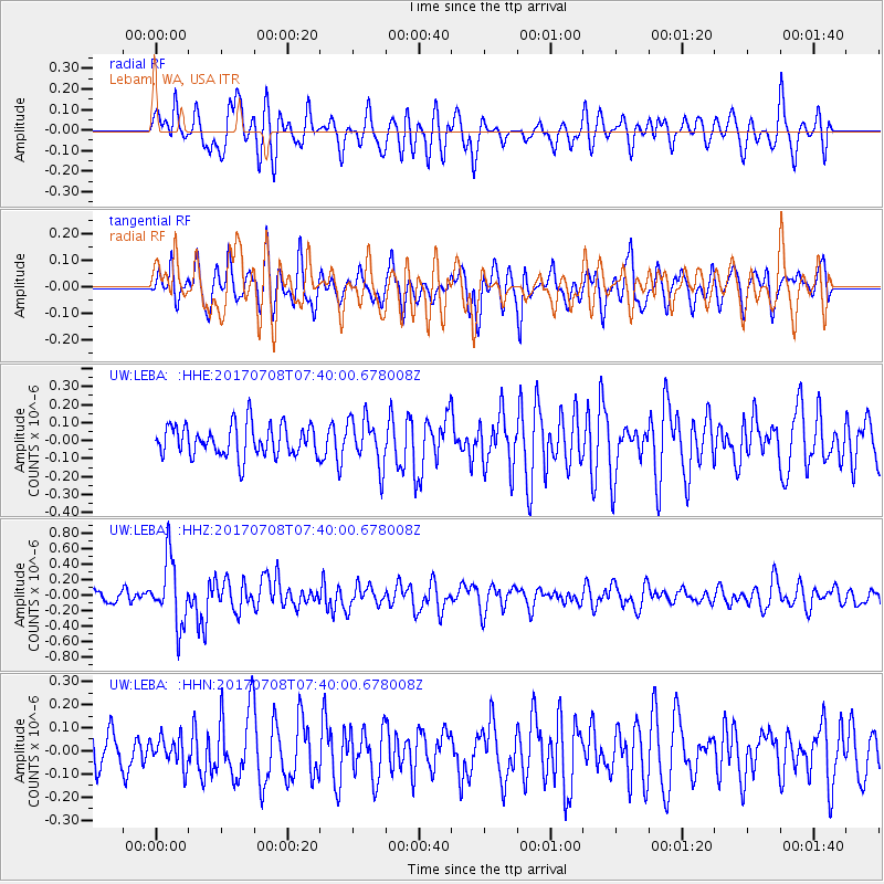
LEBA Lebam, WA, USA - Earthquake Result Viewer
*The percent match for this event was below the threshold and hence no stack was calculated.
| Earthquake location: |
Southeast Of Loyalty Islands |
| Earthquake latitude/longitude: |
-22.6/173.1 |
| Earthquake time(UTC): |
2017/07/08 (189) 07:27:35 GMT |
| Earthquake Depth: |
10 km |
| Earthquake Magnitude: |
5.6 Mww |
| Earthquake Catalog/Contributor: |
NEIC PDE/us |
|
| Network: |
UW Pacific Northwest Regional Seismic Network |
| Station: |
LEBA Lebam, WA, USA |
| Lat/Lon: |
46.55 N/123.56 W |
| Elevation: |
73 m |
|
| Distance: |
89.4 deg |
| Az: |
38.081 deg |
| Baz: |
235.684 deg |
| Ray Param: |
$rayparam |
*The percent match for this event was below the threshold and hence was not used in the summary stack. |
|
| Radial Match: |
66.54536 % |
| Radial Bump: |
400 |
| Transverse Match: |
60.287273 % |
| Transverse Bump: |
400 |
| SOD ConfigId: |
13570011 |
| Insert Time: |
2019-04-28 08:36:25.379 +0000 |
| GWidth: |
2.5 |
| Max Bumps: |
400 |
| Tol: |
0.001 |
|
Signal To Noise
| Channel | StoN | STA | LTA |
| UW:LEBA: :HHZ:20170708T07:40:00.678008Z | 6.335237 | 4.178834E-7 | 6.5961764E-8 |
| UW:LEBA: :HHN:20170708T07:40:00.678008Z | 0.6038217 | 6.157953E-8 | 1.0198297E-7 |
| UW:LEBA: :HHE:20170708T07:40:00.678008Z | 1.5099219 | 1.3163833E-7 | 8.718221E-8 |
| Arrivals |
| Ps | |
| PpPs | |
| PsPs/PpSs | |


