You are here: Home > Network List > UW - Pacific Northwest Regional Seismic Network Stations List
> Station UMAT Pilot Rock, OR, USA > Earthquake Result Viewer
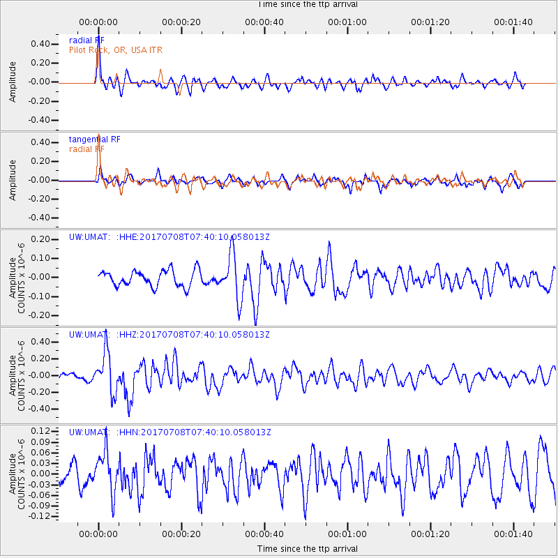
UMAT Pilot Rock, OR, USA - Earthquake Result Viewer
*The percent match for this event was below the threshold and hence no stack was calculated.
| Earthquake location: |
Southeast Of Loyalty Islands |
| Earthquake latitude/longitude: |
-22.6/173.1 |
| Earthquake time(UTC): |
2017/07/08 (189) 07:27:35 GMT |
| Earthquake Depth: |
10 km |
| Earthquake Magnitude: |
5.6 Mww |
| Earthquake Catalog/Contributor: |
NEIC PDE/us |
|
| Network: |
UW Pacific Northwest Regional Seismic Network |
| Station: |
UMAT Pilot Rock, OR, USA |
| Lat/Lon: |
45.29 N/118.96 W |
| Elevation: |
1318 m |
|
| Distance: |
91.4 deg |
| Az: |
40.872 deg |
| Baz: |
238.96 deg |
| Ray Param: |
$rayparam |
*The percent match for this event was below the threshold and hence was not used in the summary stack. |
|
| Radial Match: |
79.2272 % |
| Radial Bump: |
394 |
| Transverse Match: |
56.388454 % |
| Transverse Bump: |
360 |
| SOD ConfigId: |
13570011 |
| Insert Time: |
2019-04-28 08:36:35.735 +0000 |
| GWidth: |
2.5 |
| Max Bumps: |
400 |
| Tol: |
0.001 |
|
Signal To Noise
| Channel | StoN | STA | LTA |
| UW:UMAT: :HHZ:20170708T07:40:10.058013Z | 5.923927 | 2.4908522E-7 | 4.2047315E-8 |
| UW:UMAT: :HHN:20170708T07:40:10.058013Z | 2.0853262 | 5.8943225E-8 | 2.8265708E-8 |
| UW:UMAT: :HHE:20170708T07:40:10.058013Z | 2.9356437 | 1.2210967E-7 | 4.1595534E-8 |
| Arrivals |
| Ps | |
| PpPs | |
| PsPs/PpSs | |


