You are here: Home > Network List > TA - USArray Transportable Network (new EarthScope stations) Stations List
> Station U28A Mallet, Rita Blanca National Grassland, TX, USA > Earthquake Result Viewer
U28A Mallet, Rita Blanca National Grassland, TX, USA - Earthquake Result Viewer
| Earthquake location: |
Near Coast Of Venezuela |
| Earthquake latitude/longitude: |
10.7/-67.9 |
| Earthquake time(UTC): |
2009/09/12 (255) 20:06:24 GMT |
| Earthquake Depth: |
10 km |
| Earthquake Magnitude: |
6.3 MB, 6.4 MS, 6.3 MW, 6.3 MW |
| Earthquake Catalog/Contributor: |
WHDF/NEIC |
|
| Network: |
TA USArray Transportable Network (new EarthScope stations) |
| Station: |
U28A Mallet, Rita Blanca National Grassland, TX, USA |
| Lat/Lon: |
36.38 N/102.22 W |
| Elevation: |
1165 m |
|
| Distance: |
40.2 deg |
| Az: |
315.161 deg |
| Baz: |
120.824 deg |
| Ray Param: |
0.07454768 |
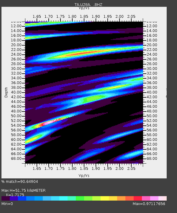
| Estimated Moho Depth: |
51.75 km |
| Estimated Crust Vp/Vs: |
1.72 |
| Assumed Crust Vp: |
6.306 km/s |
| Estimated Crust Vs: |
3.672 km/s |
| Estimated Crust Poisson's Ratio: |
0.24 |
|
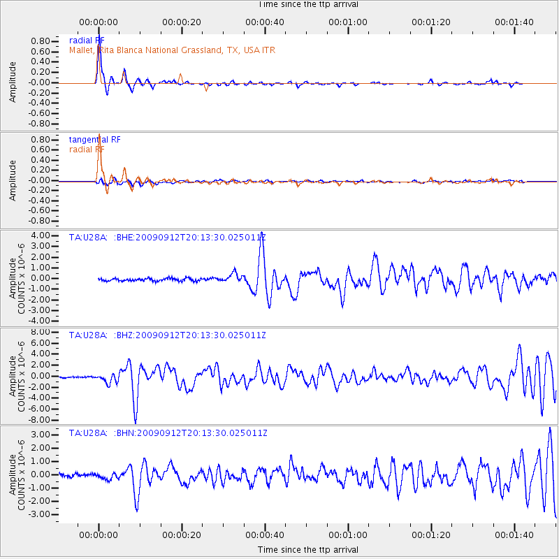
| Radial Match: |
90.64904 % |
| Radial Bump: |
213 |
| Transverse Match: |
50.870174 % |
| Transverse Bump: |
365 |
| SOD ConfigId: |
2622 |
| Insert Time: |
2010-03-06 01:43:09.475 +0000 |
| GWidth: |
2.5 |
| Max Bumps: |
400 |
| Tol: |
0.001 |
|
Signal To Noise
| Channel | StoN | STA | LTA |
| TA:U28A: :BHZ:20090912T20:13:30.025011Z | 5.859741 | 8.153464E-7 | 1.3914376E-7 |
| TA:U28A: :BHN:20090912T20:13:30.025011Z | 1.6786308 | 2.1397295E-7 | 1.2746874E-7 |
| TA:U28A: :BHE:20090912T20:13:30.025011Z | 3.6486907 | 4.295098E-7 | 1.1771614E-7 |
| Arrivals |
| Ps | 6.3 SECOND |
| PpPs | 21 SECOND |
| PsPs/PpSs | 27 SECOND |


