You are here: Home > Network List > TA - USArray Transportable Network (new EarthScope stations) Stations List
> Station U28A Mallet, Rita Blanca National Grassland, TX, USA > Earthquake Result Viewer
U28A Mallet, Rita Blanca National Grassland, TX, USA - Earthquake Result Viewer
| Earthquake location: |
Easter Island Region |
| Earthquake latitude/longitude: |
-29.1/-112.3 |
| Earthquake time(UTC): |
2009/09/17 (260) 23:21:38 GMT |
| Earthquake Depth: |
10 km |
| Earthquake Magnitude: |
5.7 MB, 6.0 MS, 6.2 MW, 6.2 MW |
| Earthquake Catalog/Contributor: |
WHDF/NEIC |
|
| Network: |
TA USArray Transportable Network (new EarthScope stations) |
| Station: |
U28A Mallet, Rita Blanca National Grassland, TX, USA |
| Lat/Lon: |
36.38 N/102.22 W |
| Elevation: |
1165 m |
|
| Distance: |
65.9 deg |
| Az: |
8.871 deg |
| Baz: |
189.623 deg |
| Ray Param: |
0.057996508 |
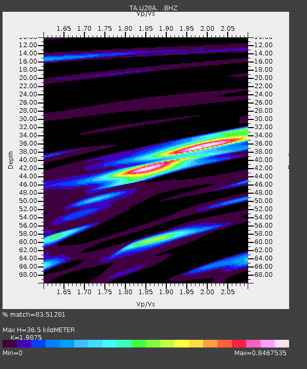
| Estimated Moho Depth: |
36.5 km |
| Estimated Crust Vp/Vs: |
1.99 |
| Assumed Crust Vp: |
6.306 km/s |
| Estimated Crust Vs: |
3.173 km/s |
| Estimated Crust Poisson's Ratio: |
0.33 |
|
| Radial Match: |
83.51281 % |
| Radial Bump: |
334 |
| Transverse Match: |
68.478096 % |
| Transverse Bump: |
400 |
| SOD ConfigId: |
2622 |
| Insert Time: |
2010-03-06 01:43:10.578 +0000 |
| GWidth: |
2.5 |
| Max Bumps: |
400 |
| Tol: |
0.001 |
|

Signal To Noise
| Channel | StoN | STA | LTA |
| TA:U28A: :BHZ:20090917T23:31:52.949016Z | 3.0738742 | 5.197947E-7 | 1.6910083E-7 |
| TA:U28A: :BHN:20090917T23:31:52.949016Z | 1.4554262 | 3.3445878E-7 | 2.2980127E-7 |
| TA:U28A: :BHE:20090917T23:31:52.949016Z | 0.89661735 | 1.3752661E-7 | 1.5338385E-7 |
| Arrivals |
| Ps | 5.9 SECOND |
| PpPs | 17 SECOND |
| PsPs/PpSs | 23 SECOND |


