You are here: Home > Network List > TA - USArray Transportable Network (new EarthScope stations) Stations List
> Station U28A Mallet, Rita Blanca National Grassland, TX, USA > Earthquake Result Viewer
U28A Mallet, Rita Blanca National Grassland, TX, USA - Earthquake Result Viewer
| Earthquake location: |
Southern Peru |
| Earthquake latitude/longitude: |
-15.0/-70.4 |
| Earthquake time(UTC): |
2009/07/12 (193) 06:12:47 GMT |
| Earthquake Depth: |
199 km |
| Earthquake Magnitude: |
5.7 MB, 6.1 MW, 6.1 MW |
| Earthquake Catalog/Contributor: |
WHDF/NEIC |
|
| Network: |
TA USArray Transportable Network (new EarthScope stations) |
| Station: |
U28A Mallet, Rita Blanca National Grassland, TX, USA |
| Lat/Lon: |
36.38 N/102.22 W |
| Elevation: |
1165 m |
|
| Distance: |
59.3 deg |
| Az: |
330.378 deg |
| Baz: |
143.718 deg |
| Ray Param: |
0.061634917 |
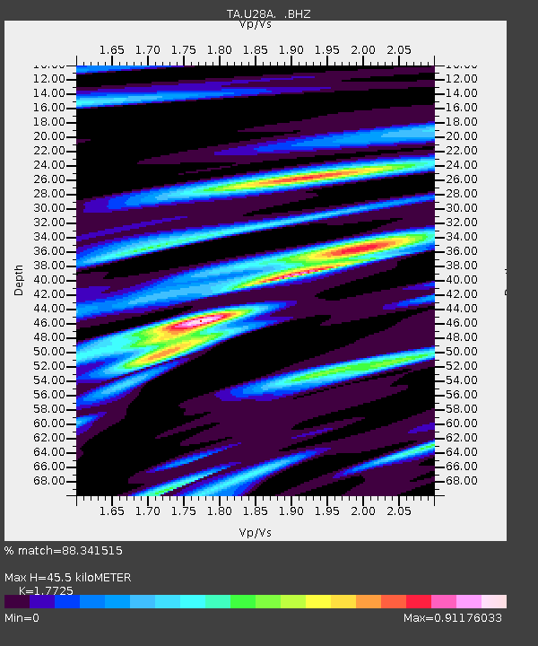
| Estimated Moho Depth: |
45.5 km |
| Estimated Crust Vp/Vs: |
1.77 |
| Assumed Crust Vp: |
6.306 km/s |
| Estimated Crust Vs: |
3.558 km/s |
| Estimated Crust Poisson's Ratio: |
0.27 |
|
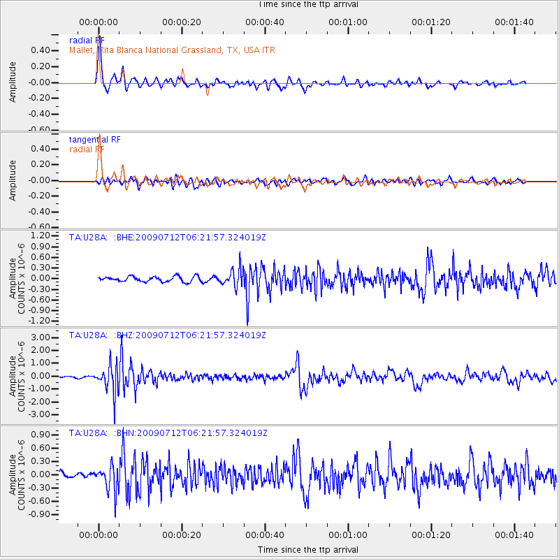
| Radial Match: |
88.341515 % |
| Radial Bump: |
380 |
| Transverse Match: |
68.9967 % |
| Transverse Bump: |
400 |
| SOD ConfigId: |
2648 |
| Insert Time: |
2010-03-06 01:43:23.629 +0000 |
| GWidth: |
2.5 |
| Max Bumps: |
400 |
| Tol: |
0.001 |
|
Signal To Noise
| Channel | StoN | STA | LTA |
| TA:U28A: :BHZ:20090712T06:21:57.324019Z | 13.986819 | 1.052992E-6 | 7.528459E-8 |
| TA:U28A: :BHN:20090712T06:21:57.324019Z | 4.4354415 | 2.8293496E-7 | 6.3789585E-8 |
| TA:U28A: :BHE:20090712T06:21:57.324019Z | 3.3839066 | 2.4526125E-7 | 7.2478734E-8 |
| Arrivals |
| Ps | 5.8 SECOND |
| PpPs | 19 SECOND |
| PsPs/PpSs | 25 SECOND |


