You are here: Home > Network List > UW - Pacific Northwest Regional Seismic Network Stations List
> Station FISH Seaside, OR, USA > Earthquake Result Viewer
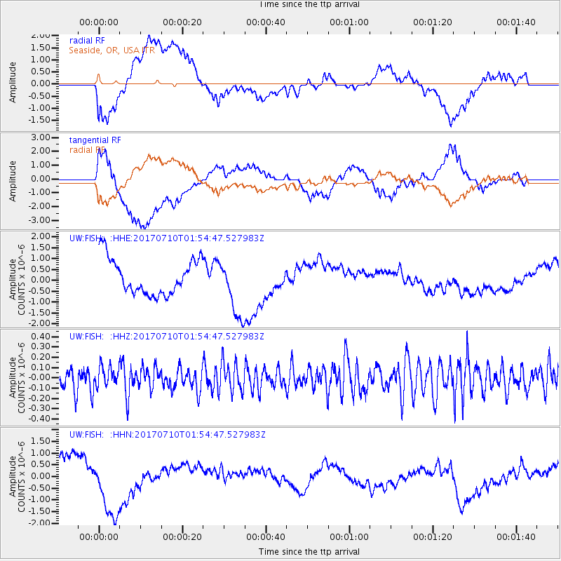
FISH Seaside, OR, USA - Earthquake Result Viewer
*The percent match for this event was below the threshold and hence no stack was calculated.
| Earthquake location: |
Leyte, Philippines |
| Earthquake latitude/longitude: |
11.0/124.8 |
| Earthquake time(UTC): |
2017/07/10 (191) 01:41:48 GMT |
| Earthquake Depth: |
7.1 km |
| Earthquake Magnitude: |
5.8 Mww |
| Earthquake Catalog/Contributor: |
NEIC PDE/us |
|
| Network: |
UW Pacific Northwest Regional Seismic Network |
| Station: |
FISH Seaside, OR, USA |
| Lat/Lon: |
45.93 N/123.56 W |
| Elevation: |
325 m |
|
| Distance: |
96.7 deg |
| Az: |
40.782 deg |
| Baz: |
293.23 deg |
| Ray Param: |
$rayparam |
*The percent match for this event was below the threshold and hence was not used in the summary stack. |
|
| Radial Match: |
43.54552 % |
| Radial Bump: |
400 |
| Transverse Match: |
42.159115 % |
| Transverse Bump: |
400 |
| SOD ConfigId: |
13570011 |
| Insert Time: |
2019-04-28 08:44:04.840 +0000 |
| GWidth: |
2.5 |
| Max Bumps: |
400 |
| Tol: |
0.001 |
|
Signal To Noise
| Channel | StoN | STA | LTA |
| UW:FISH: :HHZ:20170710T01:54:47.527983Z | 0.9262505 | 9.47566E-8 | 1.02301264E-7 |
| UW:FISH: :HHN:20170710T01:54:47.527983Z | 1.6095766 | 1.2999778E-6 | 8.076521E-7 |
| UW:FISH: :HHE:20170710T01:54:47.527983Z | 1.6522588 | 1.3559953E-6 | 8.206918E-7 |
| Arrivals |
| Ps | |
| PpPs | |
| PsPs/PpSs | |


